December 2004 LIP of the Month
Corresponds to event #233 in LIP record database.
The Fortescue Group, Western Australia; An Archaean (2.7 Ga) Large Igneous Province.
Franco Pirajno
Geological Survey of Western Australia
100 Plain Street, East Perth 6004,
Western Australia
franco.pirajno@doir.wa.gov.au
Introduction
Mantle plume-generated volcanic successions of Archaean age are difficult to recognizes in the geological record. This is primarily because of poor preservation, due to deep erosion that is likely to expose the roots (dyke swarms) or the underlying magma chambers (layered intrusions) (e.g. Ernst and Buchan 2001) or because of “mixed” signals with subdduction components (Polat et al., 1998; Wyman et al., 2002; Thurston and Ayres, 2004). In most cases Archaean flood volcanism events that can be linked to mantle plumes and that are represented in the geological record are basalts and komatiites in submarine settings (oceanic plateaux), forming what are commonly known as greenstone belts (Tomlison and Condie, 2001). There is, so far, no well-documented record of Archaean continental flood basalt-dominated volcanism (CFB), except for the ca 3.0 Ga Dominion Group lavas (at the base of the Witwatersrand Supergroup in South Africa) and two ca 2.7 Ga successions; the Ventersdorp Supergroup in South Africa and the Fortescue Group in Western Australia. The Ventersdorp (an 8-km thick succession of dominantly sub-aerially erupted tholeiitic basalts, komatiites, andesites and pyroclastics) was emplaced on the Kaapvaal Craton granitic gneiss basement and the Witwatersrand Supergroup, whereas the Fortescue was emplaced on the Pilbara Craton. The Ventersdorp and Fortescue have similar stratigraphic and compositional features, including the presence of komatiites and their near contemporaneity has led some authors (e.g. Nelson, 1998) to suggest that these ancient CFB may have been the result of a single global-scale thermal event.
Thorne and Trendal (2001) of the Geological Survey of Western Australia (GSWA) published a comprehensive review of the Fortescue volcanism, including age data, stratigraphy, volcanic and sedimentary facies analyses and geochemistry. Here the Fortescue continental flood volcanism is contributed as a “Large Igneous Province (LIP) of the Month”, and its geology and tectonic setting are briefly described. Thorne and Trendall’s bulletin is available in pdf format from the following GSWA website
http://www.doir.wa.gov.au/GSWA/597C087CABCC4F9E9D7F8A5AC17B0B2C.asp
The Fortescue flood volcanism; age and stratigraphy
The Fortescue Group is a thick succession of ultramafic, mafic, intermediate and felsic volcanic and associated volcaniclastic and sedimentary rocks, which unconformably overlies the granite-greenstone rocks of the Archaean Pilbara Craton, in the northwest of Western Australia (Figure 1). The outcrops of the Fortescue Group cover an area of about 40 000 km2. Minor intrusive units (sills and dykes) are also present and are coeval with the emplacement of the Mt. Roe Basalt, which is the lower lithostratigraphic unit (Sequence 1 in Figure 2), with SHRIMP U-Pb zircon ages from 2775 to 2663 Ma. A younger age of 2717 Ma was obtained from a rhyolite in the Maddina Formation, whereas the younger age limit for the Fortescue Group is provided by U-Pb zircon dates of 2684, 2690 Ma and an age of 2629 Ma from the top of the stratigraphically youngest lithostratigraphic unit: the Jeerinah Formation. More recent geochronology was carried out by Blake et al. (2004), with U-Pb zircon ages of felsic and mafic rocks ranging from 2766 to 2713 Ma. These authors also provide a complete listing of previous age determinations.
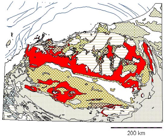
Figure 1 a: Simplified map of Pilbara Craton, showing the extent of Fortescue Group (in red); from GeoView database of the Geological Survey of Western Australia, (www.doir.wa.gov.au). North is up.
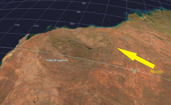
Figure 1 b: Satellite image: shows the Pilbara “egg”, note granitic plutons and compare with Figure 1a to locate the Fortescue CFB
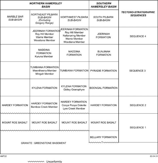
Figure 2: Fortescue lithostratigraphy; after Thorne and Trendall (2001)
The entire Fortescue Group aggregates about 6.5 km in thickness, spanning an age of about 57 Ma (Blake et al., 2004). This long geological time span suggests that several pulses of flood mafic and silicic magmatism took place in the same region. Indeed, Barley et al. (1992) suggested that the Mount Roe and Maddina sequences (Figure 2) may represent distinct continental flood basalt successions.
The Fortescue Group contains four major successions or tectono-stratigraphic sequences (Sequences 1 to 4 subdivided into seven formations; Figure 2), deposited in a number of fault-bounded sub-basins, which coalesced during the deposition of Sequence 3, ending with a major marine transgression (Sequence 4). A simplified geological map of the Fortescue Group is shown in Figure 3.
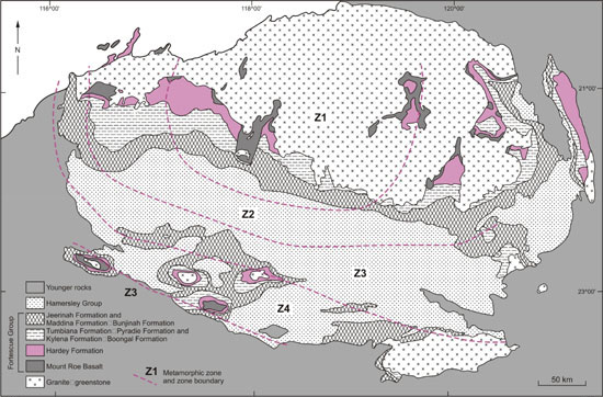
Figure 3: Simplified geological map of the Hamersley Basin and Fortescue Group, also showing burial metamorphic zones (1 prehnite-pumpellyite; 2 prehnite-pumpelyyite-epidote; 3 prehenite-pumpellyite-epidote-actinolite; 4 actinolite). After Thorne and Trendall (2001; figure 1.3).

Figure 4: Mount Roe columnar basalt; photo courtesy of Ian Williams (GSWA)
Sequence 1: The Mount Roe Basalt and Bellary Formation are the lowest and oldest unit and consist of sedimentary rocks of fan-delta, braided fluvial facies, basaltic flows and volcaniclastic rocks, aggregating about 4.5 km in thickness. The lower and upper levels of the Bellary Formation contain massive basaltic flows, hyaloclastite breccias and mafic tuff units. The Mount Roe Basalt consists dominantly of subaerial tholeiitic basaltic flows (Figure 4), massive to amygdaloidal, with lesser hyaloclastite and pillow lavas. Also present are felsic and mafic lapilli tuff at or near the base of the Formation.
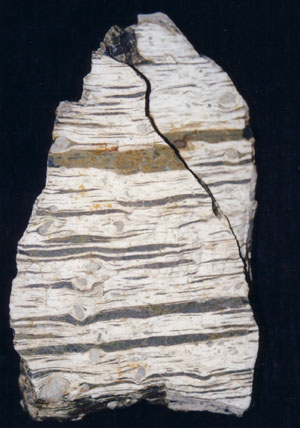
Figure 5: Ignimbrite unit of the Bamboo Creek Member, Hardy Formation; photo courtesy of Ian Williams
Sequence 2: Sequence 2 (Hardey Formation) introduces felsic volcanism and is up to 3 km thick and is associated with a consanguineous granitic plutonic complex. The Hardey Formation unconformably overlies Sequence 1. In addition to fluvial facies sedimentary units, this formation is represented by mafic and felsic volcaniclastics, basaltic flows and typically quartz-feldspar porphyries of uncertain origin. The latter are best represented by the up to 800 m thick Bamboo Creek Member, which has been interpreted as a massive pyroclastic flow deposit (Figure 5).
Sequence 3: Sequence 3 (Boongal, Pyradie and Bunjinah formations in the south and Kylena, Tumbiana and Maddina formations in the north) is from 1.5 to 3 km thick and consists mostly of tholeiitic basaltic, high-Mg basalt and komatiite rocks, which form stacked subaerial flows in the north and submarine lavas in the south, with associated felsic volcanism and clastic sedimentation. Pillow lavas of the Kylena Formation are shown in Figure 6.
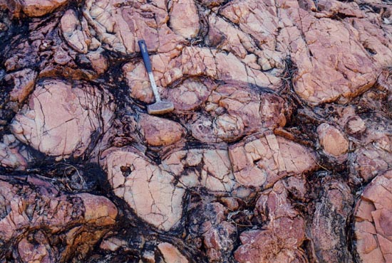
Figure 6: Pillow lavas of the Kylena Formation; photo courtesy of Ian Williams
Sequence 4: Sequence 4 (Jeerinah Formation) is less than 1 km thick and contains clastic sedimentary, subaerial and shallow marine basaltic, and volcaniclastic rocks and basaltic komatiites sills. Sequence 4 represents a major marine transgression that extended over the Pilbara Craton. The Jeerinah Formation is overlain by the BIF of the Marra Mamba Iron Formation.
Palaeogeographic and tectonic settings
Figure 7 schematically illustrates the palaeogeographic and tectonic reconstructions proposed by Thorne and Trendall (2001) during the deposition of Sequences 1, 2 and 3. The geological evolution of the Pilbara region comprises two phases of intracratonic extension and rifting between 2.7 and 2.4 Ga, with the deposition of the Fortescue Group and the overlying Hamersley Group (renowned for its extensive Superior type BIF). In terms of sequence stratigraphy the Fortescue, Hamersley and Turee Creek Groups together constitute the Mount Bruce Megasequence Set (Barley et al., 1992). Sequences 1 and 2 Fortescue lavas were erupted in isolated fault-bounded basins, accompanied by regional uplifts. These separate basins, coalesced during deposition of Sequence 3, with regional subsidence to shelf volcanism and sedimentation, culminating with a general transgression during Sequence 4 times, and the establishement of deeper shelf volcanism and sedimentation over the Hamersley Basin (Figure 7).
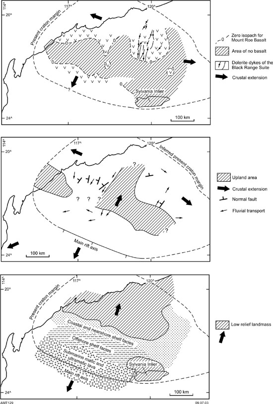
Figure 7: Palaeogeographic and tectonic setting of the Fortescue Group; after Thorne and Trendall (2001).
Economic Geology
Thorne and Trendall (2001) listed the following commodities hosted by the Fortescue Group: 1) auriferous and uraniferous pyritic conglomerates in the lower parts of the succession, with beds of gold-bearing conglomerates up to 2 m thick; 2) fluorite in fissure veins (possibly related to subjacent alkaline magmas); 3) copper-bearing quartz veins; 4) lead, silver and zinc sulphides in quartz veins and silicified faults.
The Fortescue volcanics are associated with several intrusive rocks. These include granophyres, layered mafic-ultramafic sills and dykes (Black Range Dyke, see Figure 8). The layered mafic-ultramafic sills and perhaps some of the dykes could have potential for magmatic Ni-Cu-PGE deposits. But, this possibility remains largely untested.
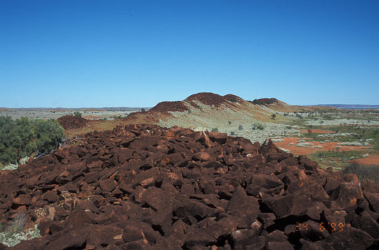
Figure 8: Black Range Dyke; photo by Franco Pirajno
The Fortescue CFB, the end result of a long-lived mantle Archaean superplume, or a series of mantle plume events? A discussion
Proxies of mantle plume events include komatiites, flood basalts, dyke swarms and layered mafic-ultramafic intrusions. Based on these proxies, a number of Precambrian superplume events have been postulated at 2.75-2.7 Ga, 2.45 Ga, and 2.0-1.9 Ga (Condie, 2004). The Fortescue and Ventersdorp are the result of the 2.75-2.7 Ga superplume event, which also coincides with the abundance of BIF at the same time (Condie, 2004 and references therein). In the Pilbara Craton, the presence of komatiites and related rocks, suggests activity of mantle plumes since about 3.5 Ga.
The northeast Pilbara Craton contains a succession of greenstone rocks, with overall synformal structures and mainly characterised by komatiites and associated felsic units, which accumulated between 3515 and 2950 Ma (see Hickman and Van Kranendonk, 2004 for review and references). Field data, supported by gravity modelling, indicate that these rocks reach a total thickness of about 14 km. In the Muccan area for example, the stratigraphy of the ca 3470-3317 Ma Warrawoona Group consists of > 2000 m of tholeiitic basalt (Mount Ada Formation), 3500 m of felsic volcanic and volcaniclastic rocks (Duffer Formation), 2000m of tholeiite and high-Mg basalts (Apex basalt), felsic volcanic rocks and chemical sediments (Panorama Formation) and about 2000 m of pillowed tholeiitic basalt, high-Mg basalt and lesser ultramafic rocks (Van Kranendonk, 1997, 1998; Williams, 1999). This entire succession is effectively a huge accumulation of mafic and felsic volcanic rocks with intercalated clastic sedimentary.and chemical rocks. The predominantly volcanic Warrawoona Group succession aggregates more than 10 km and is intruded by granodiorite and quartz-feldspar porphyry with SHRIMP U-Pb ages of 3314 and 3317 Ma, respectively. On North Shaw (Van Kranendonk, 1997, 1998), the ca 3235 Ma Sulphur Springs Group overlies the Warrawoona Formation and consists of komatiite, high-Mg basalt, pillowed basalt, volcaniclastics, lesser felsic volcanic rocks and associated sedimentary units. Hickman and Van Kranendonk (2004) proposed that the East Pilbara greenstone successions can be interpreted as submarine volcanic plateaux that were formed one above the other (layer cake style) and that subsequent deformation was the result of vertical movements due to the diapiric-style emplacement of granitoids. The ultramafic-mafic and felsic volcanic cycles of the east Pilbara are consistent with 8 mantle plume events between 3.52 and 2.94 Ga (Hickman and Van Kranendonk, 2004).
Unconformable on the youngest greenstone succession, the sedimentary, ca 2950 Ma, De Grey Group, is the Fortescue Group. Although there is a 200 Ma gap, between the youngest greenstone (Gorge Creek Group) and the first Fortescue basalt, it seems possible that the Pilbara, was the focus of repeated and dominantly submarine flood-like mafic volcanism, intermittently covering a total time span of some 800 Ma, if the Fortescue Group volcanic event is included. If correct, this hypothesis would reinforce the view that many, but by no means all, greenstone successions are the product of mantle plume events and oceanic plateaux accretion, which in the early Archaean resulted mainly in large and predominantly submarine volcanic constructs, similar to present-day oceanic plateaux (e. g. Polat et al., 1998).
Subsequent pulses of plume magmatism could have induced anatexis of the preceding volcanic plateau, resulting in the emplacement of granitic intrusions and associated felsic volcanism. The cycle could have been repeated again, with partial melting of previous-cycle granitic material as well as oceanic plateau rocks. These repeated cycles of greenstone melting at depth and remelting of earlier granitic intrusions, eventually led to the building of continental crust, setting the stage for continental flood basalt volcanism. It is after this stage that the next pulse of mantle plume magmatism acquires a distinct continental character with the eruption of the Mt. Roe basalts of the Fortescue Group. The concept outlined above is schematically illustrated in Fig. 9.
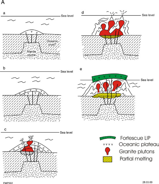
Figure 9: Conceptual model (not to scale; based on Pirajno, 2000) showing oceanic plateau accretion in the early Archaean eastern Pilbara Craton, in response to mantle plume events. In this model (A) four cycles of adiabatic melting result in the building up of four stacked oceanic plateaux (1 to 4 in a, b, c and d). With continuing mantle plume activity, heating from underplated mantle melts resulted in partial melting of earlier mafic material producing granitoid rocks (c), followed by re-melting of the mafic material and granitic rocks from the first cycle (d). These are accompanied by barite and widespread carbonate wallrock alteration, due to release of magmatic CO2 (Van Kranendonk and Pirajno, 2004). Finally, the diapiric uprise of granitic plutons produces the deformation of the oceanic plateaux rocks, forming the observed greenstone successions (d and e); the region is stabilised and becomes an emerged continent. The next pulse of mantle plume activity occurs some 200 Ma later, resulting in the emplacement of flood basalts of the Fortescue Group, which are now of continental affinity.
References
Barley, M. E., Blake, T. S., Groves, D. I., 1992. The Mount Bruce megasequence set and eastern Yilgarn Craton: examples of Late Archaean to Early Proterozoic divergent and convergent craton margins and controls on mineralisation. Precambrian Research, 58, p. 55-70.
Blake, T. S., Buick, R., Brown, S. J. A., Barley, M. E., 2004. Geochronology of a Late Archaean flood basalt province in the Pilbara Craton, Australia: constraints on basin evolution, volcanic and sedimentary accumulation, and continental drift rates. Precambrian Research, 133, p. 143-173.
Condie, K. C., 2004. Precambrian superplume events, in Eriksson, P. G., Altermann, W., Nelson, D. R., Mueller, W. U., Catuneanu, O. (eds), The Precambrian Earth: tempos and events, Developments in Precambrian Geology 12, p. 163-180, Elsevier, Amsterdam.
Ernst, R. E., Buchan, K. L., 2001. Large mafic magmatic events through time and links with mantle plume heads. Geological Society of America Special Paper 352, p. 483-576.
Hickman, A. H., Van Kranendonk, M., 2004. Diapiric processes in the formation of Archaean continental crust, East Pilbara granite-greenstone terrane, Australia, in Eriksson, P. G., Altermann, W., Nelson, D. R., Mueller, W. U., Catuneanu, O. (eds), The Precambrian Earth: tempos and events, Developments in Precambrian Geology 12, p. 118-139, Elsevier, Amsterdam.
Nelson, D. R., 1998. Granite-greenstone formation on the Archaean Earth: a consequence of two superimposed processes. Earth and Planetary Science Letters, 158, p. 109-119.
Pirajno, F. 2000. Ore deposits and mantle plumes. Kluwer Academic Publishers, Dordrecht.
Polat, A., Kerrich, R., Wyman, D. A., 1998. The Late Archean Schreiber-Hemlo and White River-Dayahessarah greesnstone belts, Superior Province; collages of oceanic plateau, oceanic arcs and subduction-accretion complexes. Tectonophysics, 289, p. 295-326.
Thorne, A. M., Trendall, A. F., 2001. Geology of the Fortescue Group, Pilbara Craton, Western Australia. Geological Survey of Western Australia Bulletin 144, 249 pp.
Thurston, P. C., Ayres, L. D., 2004. Archaean and Proterozoic greenstone belts: setting and evolution. in Eriksson, P. G., Altermann, W., Nelson, D. R., Mueller, W. U., Catuneanu, O. (eds), The Precambrian Earth: tempos and events, Developments in Precambrian Geology 12, p. 311-333, Elsevier, Amsterdam.
Tomlison, K. Y., Condie, K. C., 2001. Archean mantle plumes: evidence from greenstone belt geochemistry. Geological Society of America Special Paper 352, p. 341-357.
Van Kranendonk, M. J., 1997. Results of field mapping, 1994-1996 in the North Shaw and Tambourah 1:100 000 sheet areas, eastern Pilbara Craton, norttwestern Australia. Australian Geolgical Survey Organisation Record 197/23.
Van Kranendonk, M. J., 1998. Litho-tectonic and structural map componenets of the North Shaw 1: 100 000 sheet, Archaean Pilbara Craton. Geological Survey of Western Australia Annual Review 1997-98, p. 63-70.
Van Kranendonk, M. J. Pirajno, F., 2004. Geochemistry of metabasalts and hydrothermal alteration zones associated with c. 3.45 Ga cher5t and barite deposits: implications for the geological setting of the Warrawoona Group, Pilbara Craton, Australia. Geochemistry: Exploration, Environment, Analysis, 4, p. 253-278.
Williams, I. R., 1999. Geology of the Muccan 1:100 000 sheet. Geological Survey of Western Australia Explanatory Notes.
Wyman, D. A., Kerrich, R., Polat, A., 2002. Assmebly of Archean cratonic mantle lithosphere and crust: plume-arc interaction in the Abitibi-Wawa subdution-accretion complex. Precambrian Research, 115, p. 37-62.