July 2004 LIP of the Month
(corresponds to event 220 in LIP record database)
Remnants of an Archean Large Igneous Province: Evidence from the komatiite-bearing greenstone belts of the northern Rae domain, Nunavut, Canada
Trevor MacHattie (trevor@UAlberta.ca)
Larry Heaman (Larry.Heaman@UAlberta.ca)
Robert Creaser (Robert.Creaser@UAlberta.ca)
Dept. of Earth and Atmospheric Sciences, University of Alberta
Edmonton, Alberta
Tom Skulski (tskulski@NRCan.gc.ca)
Geological Survey of Canada
Ottawa, Ontario
Hamish Sandeman (hsandeman@NRCan.gc.ca)
Canada-Nunavut Geoscience Office
Iqaluit, Nunavut
Introduction
The definition of a large igneous province (LIP) is tied not only to its large size (a hundred thousand to one million square kilometres of mafic-ultramafic magma) and overall rapid rate of formation (may be 10s of Ma in duration, although punctuated by rapid large volume eruptions), it is also linked to inferred geodynamic setting. By definition, LIPs are not associated with “normal” sea floor spreading or subduction-related processes. With these qualifications in hand, LIP are widely recognized in the Phanerozoic (e.g., Siberian and Deccan Traps), less so in the Proterozoic (e.g., Circum-Superior and Warakurna LIPs), and rarely in the Archean. Mesozoic continental flood basalts and oceanic plateaux younger than the oldest oceanic crust are the most easily recognized LIPs because they are well preserved and are close to their original size. The formation of LIPs is often linked with mantle plumes, largely because unusually hot mantle seems to be necessary (in some cases) to generate the large volumes of melt, and unusual crustal thicknesses (e.g., Ontong Java Plateau). The identification of a LIP becomes progressively harder the further back in time we go, and this is in part due to the lower degree of preservation of older sequences. For example, Archean volcanic rocks and associated intrusives preserved in greenstone belts have generally experienced multiple episodes of deformation and metamorphism and may be extensively eroded. This makes it difficult to not only unravel the original stratigraphic relationships and place a precise timing to magmatic events on a regional scale, but also the original thicknesses and aerial extent of volcanic successions may be impossible to accurately determine. To classify a particular Archean greenstone belt as a LIP, one would have to demonstrate the occurrence of contemporaneous mafic-ultramafic magmatism over an extensive region, provide evidence of the geodynamic setting of magmatism, and evaluate the petrological and geochemical evidence for large degrees of melting and rapid and voluminous eruptions. If this can be done, potential insights into the formation and evolution of LIPs through time may be obtained.
Regional Geology and Geochronology of the PAG-WLG
The volcanic and sedimentary rocks of the Prince Albert and Woodburn Lake Groups (PAG and WLG, respectively) form part of a continuous, northeast trending, komatiite-dominated greenstone belt succession within the northern Rae domain of Nunavut (Schau, 1977, Schau and Ashton, 1988; Schau, 1997). Together, the belts have a strike length of over 1000 km and cover an area (enveloping limit of exposure) of about 2 x 10⁵ km2 (Figure 1). The belts may however, have correlatives ~ 500 km toward the northeast on Baffin Island, where similar aged rocks known as the Mary River Group contain iron formation, quartzite, schist, metabasalt, and locally meta-ultramafic rocks rest upon older (< 150 Ma) basement (Jackson et al., 1990; Bethune and Scammell, 2004). However, not enough is currently known of the nature, abundance, and precise age of ultramafic rocks of the Mary River group to confidently correlate them with the WL and PAG successions.
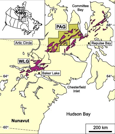
Figure 1: Location of ca. 2.73-2.69 Ga komatiite-bearing greenstone belts of the northern Rae province of Nunavut. The location of the Woodburn Lake (WLG), and Prince Albert (PAG) Groups are indicated, as are the boundaries of the 2000-2003 map area.
It has been suggested by Zaleski et al. (2001) that the Rae Province greenstone belts formed as a result of continental rifting and upwelling of plume-related mantle derived magmas. The evidence for a rift setting is based on the bimodal (ultramafic-mafic and felsic) nature of volcanism, intercalated ultramafic-mafic volcanics and terrigenous sedimentary rocks, and a locally preserved Mesoarchean (~2.87 Ga) basement complex (Zaleski et al., 2001). These observations were derived from the WLG, and extrapolated along strike to the PAG, mainly because of the known presence of komatiite in that area (despite the lack of geochronology, at the time). Our mapping within the PAG between 2000-2003 (Sandeman et al., 2001; Skulski et al., 2002; Skulski et al., 2003a) and subsequent U-Pb geochronology and geochemistry of ultramafic-mafic magmatism largely corroborates the interpretation of a volcanic continental margin setting (Skulski et al., 2003b) and confirms that the two belts are contemporaneous, having similar U-Pb ages of felsic (and associated ultramafic-mafic) volcanism ranging between 2730-2690 Ma, (2690 Ma age preserved as zircon population in WLG sediments; Davis and Zaleski, 1998).
The geochemical and tracer isotopic study of PAG ultramafic-mafic magmastism, is also yielding important insights into the nature of the mantle source(s), dynamics of the partial melting processes(s), the degree of lithospheric reworking during magmatism, and the potential role of mantle plumes in the formation of greenstone belts.
Volcanology of PAG Komatiite and Basalt
The 2730-2690 Ma magmatism within the PAG is distinctly bimodal; ultramafic-mafic lavas dominate with lesser dacitic-rhyolitic flows, epiclastics and associated shallow porphyries. The majority of ultramafic rocks in the belt are differentiated, peridotitic lava flows, that have upper portions composed of spinifex textured olivine and lower portions comprised of cumulus polyhedral olivine (plate 1).
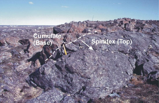
Plate 1: Spinifex-textured komatiite lava flow. The spinifex-textured upper portion weathers grey-green and the cumulate base weathers rusty brown. This flow is overturned. Hammer is ~ 50 cm long.
Spinifex textured flows vary widely in their character, particularly in their thickness. Some are as thin as 30 centimeters, while others are > 50 meters, although the majority have thicknesses between 2 and 10 meters. In some of the thickest flows, composite ‘books’ comprised of several olivine plates are greater than 1 meter in length (plate 2).
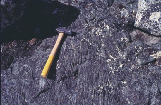
Plate 2: Coarse plate of olivine spinifex from the upper portion of a thick (> 20 m) komatiite flow. Hammer is ~ 50 cm long.
Although spinifex-textured lava flows predominate, pillowed (plate 3) as well as thick, coarse-grained olivine-rich cumulate flow units are common. Some of the thick olivine-rich cumulate bodies have lenticular forms and truncate adjacent thin spinifex-textured flows and may be remnant lava channels. Many outcrops are composed of fine grained cumulate-textured komatiite similar in character to the basal portions of spinifex textured flows and could be lava flows or shallow intrusions. The variety of komatiite flow types and their complex intercalations suggest a dynamic and evolving volcanic setting. The thickest flows and lava channels indicate large volumes and rapid rates of magma supply, suggesting proximity to a vent (MacHattie, 2002).
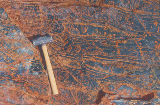
Plate 3: Elongate pillows at the top of a komatiite flow unit. Hammer is ~ 50 cm long.
Interlayered with the komatiite are relatively smaller volumes of komatiitic basalt and basalt, and form thin flows in comparison to the komatiites. Komatiitic basalts may exhibit differentiation into lower zones comprised of olivine, pyroxene, and plagioclase, and upper spinifex-textured zones of needle-like pyroxene, while others have ovoid polyhedra and fractured flow tops similar to those observed in the komatiites. Intercalated basalts are massive, and rarely pillowed.
Geochemical Framework
We collected and analysed ~ 200 samples of komatiite, komatiitic basalt, basalt, gabbro, and felsic-intermediate volcanics for major and trace element contents. Approximately 50 samples were analysed for Sm-Nd isotopic compositions, and we have obtained preliminary Lu-Hf isotopic data for some komatiites and basalt. The samples were collected along a 300 km strike length (see Figure 1), and throughout the entire 2730-2690 Ma volcanic stratigraphy.
In the following discussion we want to give a brief overview of some of the key “primary” geochemical and isotopic signatures obtained from komatiite and basalt that provide information about the nature and evolution of the mantle source. In this case we must eliminate samples that have experienced varying degrees of contamination by the continental crust. This is particularly important because the incompatible trace element contents and key ratios (useful as petrogenetic indicators) of komatiite and basalt show considerable variability, and some of this is due to contamination. It is almost impossible to say that any particular sample in this type of volcanic setting is uncontaminated, and in fact many samples probably do contain minor amounts of crust.
Fortunately, the effects of minor crustal additions to komatiite has virtually no effect on certain incompatible element ratios (e.g., Gd/Yb), a moderate effect on some (e.g., Ce/Sm), and can dramatically alter others (e.g., increase greatly Th/Nb). This provides a way to monitor the degree, and subsequent effects of contamination provided an uncontaminated sample can be identified. The most incompatible element depleted komatiites sampled in the belt have mantle normalized (subscripted “N”) Th/NbN ~ 0.4, Ce/SmN ~ 0.4, and Gd/YbN ~ 1. The addition of 0-2 % average upper continental crust to these komatiite does increase Th/NbN and Ce/SmN, although importantly they remain < 1, and no significant change occurs to the Gd/YbN ratio. From the examination of mantle normalized extended element plots, the subdivision of basalt and komatiite into contaminated and uncontaminated reveals that ~ 50 % of the basalts collected have Th/NbN >/>>1, and some contain significant quantities of crust. In the case of komatiite, only one group of samples collected from the same outcrop consistently have Th/NbN >1 (1.0-2.4). Samples with Th/NbN è 1 (basalt and komatiite) are either uncontaminated or only assimilated small quantities of crust.
Komatiite
Spinifex-textured and aphyric komatiites have MgO contents that range between 22-30 wt. %, with cumulate textured samples having values as low as 26 and as high as 40 wt. %. The chemical variation observed between samples collected from the same lava flow can be shown to be largely controlled by olivine-dominated fractionation. When plotted on variation diagrams versus MgO the high field strength elements (HFSE), TiO2, Al2O3 and Fe2O3T (as total iron) are well correlated, and small deviations are probably due to some MgO mobility. Key features of the chemical compositions of PAG komatiites that cannot be attributed to olivine fractionation are the wide ranges in Fe2O3T, Al2O3/TiO2 and Gd/YbN. Komatiites have Fe2O3T between ~ 9 and 16 wt. %. This range is represented by spinifex- and cumulate-textured komatiite, having a relatively limited range in MgO content (25-35 wt. %). The Al2O3/TiO2 ratio ranges between 16 and 30, and is largely controlled by small variations in the TiO2 content. Komatiites also display a wide range in the degree of heavy rare earth element (HREE) fractionation (Figure 2), having Gd/YbN values ranging between 0.5-1.3, although most are between 0.8 and 1.3, with the lowest values exclusively associated with highly “non-liquid” magnesian cumulates (MgO > 36 wt. %). Good correlations exist between Gd/YbN and Al2O3/TiO2, Fe2O3T, and MgO (MgO correlation using “near-liquid” random spinifex-textured komatiite). The most HREE depleted samples (high Gd/YbN) have the highest Fe2O3T, and lowest MgO and Al2O3/TiO2.
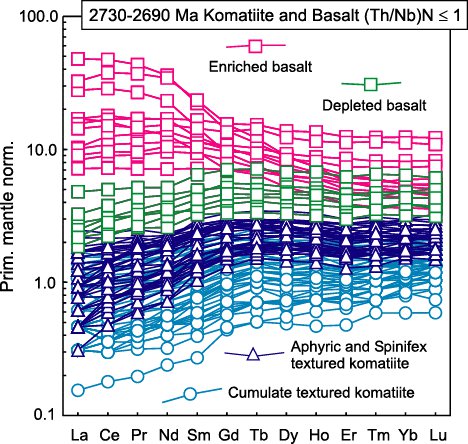
Figure 2: Primitive mantle normalized rare earth element (REE) plot for uncontaminated 2730-2690 Ma komatiites and basalts.
Basalt and Gabbro
Uncontaminated basalts and cogenetic gabbros have MgO contents ranging between 5 and 13 wt. %, averaging around ~8 wt. %, and can be classified as sub-alkaline tholeiites. For the most part, major element compositions are relatively homogeneous, although this is certainly not the case for the minor and trace elements. Basaltic rocks have wide variation in fractionated rare earth element (REE) patterns (Ce/SmN = 0.6-2.1; Gd/YbN = 1.0-3.2; Figure 2), an overall wide range in TiO2 (0.5-3.0 wt. %), and consequently have variable Al2O3/TiO2. Excluding cumulate textured gabbroic samples (excess plagioclase-high Al2O3), it can be seen that LREE depleted basalts have low TiO2 (0.5-1.0 wt. %), relatively unfractionated HREE (Gd/YbN = 1.0-1.2) and the highest Al2O3/TiO2 (14-20), whereas LREE enriched samples, have high TiO2 (1.3-3.0 wt. %), are HREE depleted (Gd/YbN = 1.2-3.2), and have low Al2O3/TiO2 (5-9). As with the komatiites, the Al2O3/TiO2 of basalts is largely controlled by variable TiO2 contents and not obviously related to Al depletion or enrichment.
Isotopic data
Despite the wide range in both the major and trace element composition of PAG basalts and komatiites, all uncontaminated samples have similarly depleted Nd and Hf isotopic compositions, and when plotted on Sm-Nd and Lu-Hf isochron diagrams, yield ages consistent with the U-Pb zircon ages of felsic volcanics. Crustally contaminated basalts and komatiites, as well as dacitic-rhyolitic lavas (Th/NbN >/>>1) also have depleted Nd isotopic signatures, attesting to the juvenile nature of the crustal contaminant. This conclusion is supported by the dominant age of zircon inheritance (< 150 Ma older) found in two ca. 2730 Ma felsic volcanics. As the wide range in HFSE fractionation (eg., Gd/YbN) observed in basalts and komatiites cannot be the result of contamination (especially the minor amount suggested by the low Th/NbN values), and both rock types have the same Nd and Hf isotopic compositions, this suggests that REE-HFSE fractionation, and consequently the correlation of major and minor element abundances, is due to partial melting phenomena (MacHattie et al., 2004).
Summary and Conclusions
The komatiite-bearing greenstone belts of the northern Rae domain of Nunavut are the erosional remnants of an extensive late Archean ultramafic-mafic magmatic event, covering a minimum extent of ~ 2 x 10⁵ km2. Komatiitic magmas were generated throughout the entire ~ 40 Ma of preserved magmatic history and dominate the volcanism, an unusual feature considering komatiites are almost always subordinate to, or rare in comparison to the larger volumes of tholeiitic basalt occurring in most greenstone belts (eg., Abitibi, see Sproule et al., 2002). Volcanism was punctuated, initiating at ~ 2730 Ma, with subsequent felsic-ultramafic(-mafic) magmatism persisting to ~ 2690 Ma. The available evidence suggests the setting of volcanism was an extensive (> 1000 km long) volcanic continental rift zone developed on juvenile (< 100-150 Ma older) continental crust.
Major, trace and isotopic data suggest a common moderately depleted mantle source for PAG basalts and komatiites, and that melting of this mantle was initiated within the garnet stability field (e.g., high Gd/YbN). The production of magmas with such a wide range in incompatible element ratios, and having similar isotopic compositions suggests the melting regime was complex and capable of producing a diversity of magmas from the same mantle source.
A potential modern analogue to the PAG komatiite and basalt (with respect to their geochemical fractionations, not geodynamic setting) may be found in the Cretaceous basalts and komatiites outcropping on Gorgona Island, part of the Caribbean-Colombian oceanic plateaux. Gorgona komatiite and basalt also display a wide range in incompatible element ratios, with both enriched and depleted basalts, and strongly depleted komatiites and picrites, similar to the PAG lavas. Arndt et al. (1997) proposed a dynamic melting regime to explain the formation of Gorgona lavas, involving continuous mantle melting and melt extraction, and the pooling and mixing of magmas at the top of the melt column (base of the lithosphere). The continuous extraction of melts (near fractional) produces a very refractory source, which upon further melting yielded the strongly incompatible element depleted komatiite and picrite.
As the Gorgona komatiites and basalts are interpreted as the melting products of a mantle plume, one might also suggest that the PAG magmas were also the melt products of a mantle plume, and this could certainly be the case. However, we must consider the possibility that the PAG magmatism was not related to a mantle plume. Experimental melting studies of fertile garnet peridotite (Walter, 1998) show that komatiitic melts can be generated at moderate pressures, and at relatively low degrees of melting. For example, at 5 GPa pressure and ~ 10 % batch melting, the MgO content of the melt generated is ~ 22 wt. %, and FeO ~ 12 wt. %, similar to the compositions of the komatiites with the lowest MgO content. In fact, at 4 GPa under similar degrees of melting (~ 10 %) the melts are still komatiitic (MgO é 18 wt. %). If melting of a moderately depleted mantle started at these pressures, and was near fractional, we could expect a diversity of incompatible element enriched/depleted high-MgO melts, and strongly depleted komatiites to be produced if melting continued to lower pressures and the homogenization of melt increments was incomplete. If PAG komatiites and basalts can be produced by melting that started at 4-5 GPa pressures, perhaps continental extension and decompression melting of passively upwelling mantle played an important role. If so, this may question the need for mantle plume involvement.
The details of the proposed melting models and more information on the nature of the Prince Albert and Woodburn Lake Groups will be included in a paper currently being prepared for submission and publication. This research forms part of the ongoing PhD research of Trevor MacHattie.
References
Arndt, N.T., Kerr, A.C., and Tarney, J. 1997. Dynamic melting in plume heads: the formation of Gorgona komatiites and basalts. Earth and Planetary Science Letters 146: 289-301.
Bethune, K.M., and Scammell, R.J. 2003. Geology, geochronology, and geochemistry of Archean rocks in the Eque Bay area, north-central Baffin Island, Canada: constraints on the depositional and tectonic history of the Mary River Group of northeastern Rae Province. Canadian Journal of earth Sciences 40: 1137-1167.
Davis, W.J, and Zaleski, E. 1998. Geochronological investigations of the Woodburn Lake group, western Churchill Province, Northwest Territories: preliminary results; In Radiogenic Age and Isotopic Studies: Report 11; Geological Survey of Canada, Current Research 1998-F, p. 89-97.
Jackson, G.D., Hunt, P.A., Loveridge, W.D., and Parrish, R.R. 1990. Reconnaissance geochronology of Baffin Island, N.W.T.; in Radiogenic Age and Isotopic Studies: Report 3, Geological Survey of Canada, Paper 89-2, P. 123-148.
MacHattie, T.G. 2002. Physical volcanology of komatiite in the Laughland and Walker Lake areas, Committee Bay belt, Nunavut; Geological Survey of Canada, Current Research 2002-C14, 7p.
MacHattie, T.G., Heaman, L.M., Creaser, R.A., Skulski, T., and Sandeman, H.A. 2004. Dynamic melting in an Archean mantle plume: chemical signature of Prince Albert Group komatiite and basalt, Nunavut, Canada. Abstract in 13th Annual V.M. Goldschmidt Conference, Copenhagen, Denmark. GCA: 68, no. 11S, p. A595.
Sandeman, H.A., Brown, J., Studnicki-Gizbert, C., MacHattie, T.G., Hyde, D., Johnstone, S., Greiner, E., and Plaza, D. 2001. Bedrock mapping in the Committee Bay belt, Laughland Lake area (NTS 56K) central mainland, Nunavut; Geological Survey of Canada, Current Research 2001-C12, 28p.
Schau, M., 1977. "Komatiites" and quartzites. In: Volcanic Regimes in Canada, Ed. W.R.A. Baragar, L.C. Coleman, and J.M. Hall. Geol. Assoc. Can. Spec. Paper 16, p. 341-354.
Schau, M. 1997. Geology of the Archean Prince Albert Group in the Richards Bay area, northeastern Melville Peninsula, District of Franklin, Northwest Territories. Geological Survey of Canada Bulletin, 44 p.
Schau, M., and Ashton, K.E. 1988. The Archean Prince Albert Group, northeastern Canada: evidence for crustal extension within a >2.9 Ga continent. [abstract] Geological Society of America Abstracts With Program, v. 20, p. A50.
Skulski, T., Sandeman, H., Sanborn-Barrie, M., MacHattie, T.G., Hyde, D., Johnstone, S., Panagapko, D., and Byrne, D. 2002. Contrasting crustal domains in the Committee Bay Belt, Walker Lake-Arrowsmith River area, central mainland Nunavut; Geological Survey of Canada, Current Research 2002-C11, 11p.
Skulski, T., Sandeman, H., Sanborn-Barrie, M., MacHattie, T., Young, M., Carson, C., Berman, R., Brown, J., Panagapko, D., Byrne, D., and Deyell, C. 2003a. Bedrock geology of the Ellice Hills (NTS 56P), and new constraints on the regional geology of the Committee Bay area, Nunavut; Geological Survey of Canada, Current Research 2003-C22, 13p.
Skulski, T., Sandeman, H., MacHattie, T.G., Sanborn-Barrie, M., Rayner, N., and Byrne, D. 2003b. Tectonic setting of 2.73-2.7 Ga Prince Albert Group, Churchill Province, Nunavut. GAC-MAC Joint Annual meeting (Vancouver), Abstract Volume 28.
Sproule, R.A., Lesher, C.M., Ayer, J.A., Thurston, P.C. and Herzberg, C.T. 2002. Spatial and temporal variations in the geochemistry of komatiites and komatiitic basalts in the Abitibi greenstone belt. Precambrian Research 115: 153-186.
Walter, M.J. 1998. Melting of Garnet Peridotite and the Origin of Komatiite and Depleted Lithosphere. Journal of Petrology 39: 29-60.
Zaleski, E., Davis, W.J., and Sandeman, H.A. 2001. Continental extension, mantle magmas and basement/cover relationships. In: Proceedings of the Fourth International Archean Symposium 2001, Extended Abstracts, Ed. Cassidy, K.F., Dunphy, J.M., and Van Kranendonk, M.J.; AGSO-Geoscience Australia, Record 2001/37, p. 374-376.