October 2005 LIP of the Month
Corresponds to event #49 in LIP record database.
The Late Early Cambrian Kalkarindji Continental Flood Basalt Province: A Link To Mass Extinction
Lena Z. Evins
School of Earth Sciences, James Cook University, Townsville QLD 4811, Australia
Email: lena.evins@jcu.edu.au
Introduction
Recently data has emerged indicating that the Antrim Plateau Volcanics of northern Australia and their counterparts erupted in the Early Cambrian, rather than in the Neoproterozoic as previously thought (Hanley and Wingate, 2000; Glass, 2002). This new age is exciting, because it appears to be coeval with the end Early Cambrian mass extinction. During this time, Early Cambrian reef-builders (mainly Archeocyatha) and reef-dwellers (trilobites and other creatures) worldwide suffered a severe extinction (eg Zhuravlev and Wood, 1996).
Bultitude (1976), who studied the Antrim Plateau Volcanics and the smaller basaltic outcrops throughout the area (Nutwood Downs Volcanics, Helen Springs Volcanics, Peaker Piker Volcanics, Colless Volcanics), suggested that these basalts were in fact part of the same province (Fig.1). New geochemical data from the different outcrops support his theory that they are identical. An Ar-Ar age of ca. 510 Ma from feldspar from Helen Springs Volcanics and the Antrim Plateau Volcanics was recently produced (Glass, 2002;Glass et al, 2004). The 513±13 Ma Milliwindi dyke further to the west in the Kimberleys has the same geochemistry (Hanley and Wingate, 2000) and is considered to be a feeder dyke to the province. This information was enough to allow Linda Glass (formerly Hanley), who studied these basalts during her PhD thesis, to group them together as a Large Igneous Province called the Kalkarindji Continental Flood Basalt Province (Glass, 2002; Glass et al, 2004). The geochemistry and isotope geology of the Kalkarindji CFBP will be the subject of a later “LIP of the Month” by Linda Glass, so keep checking this web site for further information on this province.
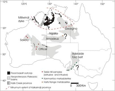
Figure 1: Overview of the Kalkarindji Continental Flood Basalt Province and suggested correlated mafic igneous rocks, based on maps and information in Walter et al (1995), Chen and Liu (1996), Hanley and Wingate (2000), Williams and Gostin (2000), Gole (2001) and Buick et al (2005). Question marks indicate areas with mafic rocks recently suggested as parts of the Kalkarindji flood basalt province (Ernst and Buchan, 2003; Buick et al, 2005).
Links to mass extinction
The temporal correlation between LIPs and mass extinctions (i.e. Courtillot and Renne, 2003) is quite striking. With the new data from the Kalkarindji province, this correlation is extended even further back in time (Fig.2) to show that the first major Phanerozoic mass extinction occurred around the same time as the eruption of the lavas in northern Australia. These remarkable temporal links bring up some interesting questions: did these LIPs trigger drastic global environmental changes that caused mass extinction? One clue would be the gas flux into the atmosphere during the eruptions. Unfortunately, this is not an easy thing to determine. It requires knowledge of original volume of magma erupted (related to the extent of the province, discussed below), amount of pre-eruptive volatiles in the magma, and the duration of the eruptions. Also of importance is the type of volcanism: how much of the magma was erupted explosively? In addition, there is a possibility that gases will be emitted not only from the erupting magma, but from the rock formations they heat up during emplacement. One example is the coal bearing strata in Southern Gondwana, which were intruded and heated by the magmas of the Karroo-Ferrar LIP, resulting in the release of 2600-4400 Gt of carbon into the atmosphere (McElwain et al, 2005). In relation to this, it is interesting to note that the basaltic magmas of the Table Hill Volcanics, possible correlatives of the Kalkarindji basalts (Fig 1.), have been contaminated by a gypsum-bearing (S-rich) mudrock in the intruded sedimentary sequence (Gole and Thornett, 2003). This might have implications for the volatile composition of the Table Hill magmas, as well as volatiles released during contact metamorphism.
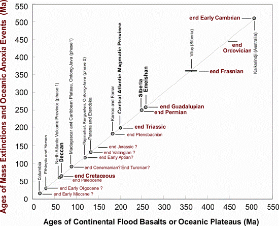
Figure 2: Correlation between LIPs and mass extinctions, from Shields and Evins (2004). The figure is modified from Courtillot and Renne (2003) in order to show the extension of this correlation deeper in time, to the Cambrian.
The exact composition of the volatile mix erupted by the Kalkarindji province is not known, but pending fluid inclusion and melt inclusion work will hopefully reveal this information. It is clear from the study of Gole and Thornett (2003), that there may be quite pronounced differences in the final chemistry of the erupting magmas, and related volatiles, in different areas depending on local geology.
Another important approach in the search for a link between LIPs and mass extinction is to look for signs of environmental change in coeval sedimentary rocks. The trick is to find good biostratigraphically constrained sedimentary sections that record the mass extinction, and lend themselves to chemostratigraphical analysis. The Cambrian is especially challenging in this aspect due to a dearth of radiometric ages and difficult intercontinental correlations. Data from North America indicate major changes of C isotopic composition in seawater around the Early-Middle Cambrian boundary (Montañez et al, 2000), a possible sign of climate change. Ongoing work at James Cook University on the isotopic composition of S in Australian early Middle Cambrian sedimentary rocks also indicate a drastic climate change around the same time. S isotopic compositions in the oceans are changed by the oxygen level, which in turn correlate to the climate: warm oceans have lower oxygen solubility. Shifts in the S isotopic composition of the ocean have been noted by other authors in sections coeval with the Permian-Triassic (Holser, 1977; Kump et al, 2005) and the Paleocene-Eocene boundaries (Kurtz et al, 2003), both of which are related to mass extinctions and LIPs.
Extent of the province
Undoubtedly, the size of a LIP is important in determining the environmental impact of the related volcanism. The Kalkarindji Continental Flood Basalt Province stretches from Queensland in the East to the Kimberley area in Western Australia and underlies a large part of the Paleozoic rocks of the Daly River, Wiso and Georgina basins (Fig 1). It is estimated that the province covers at least 300 000-400 000 km2 (comparable to the Emeishan LIP; Eldholm and Coffin, 2000) but this is a minimum estimate and there is a strong possibility that the extent of the province is much larger. The Boondawari dolerite dyke, in the Savory basin, Western Australia (Fig.1), was emplaced at 508±5 Ma (Macdonald et al, 2005) and is considered to be part of the province. The Table Hill Volcanics in the Officer basin, Western Australia, is commonly believed to be coeval and related to the Kalkarindji flood basalts; this is mainly based on geochemistry (Gole, 2001; Glass 2002) and stratigraphic relationships (e.g. Haines et al, 2001). However, the age of the Table Hill Volcanics needs to be resolved, and this work is in progress. In addition, a couple of more areas have recently been suggested to be part of the Kalkarindji Continental Flood Basalt Province (Fig 1.).
Buick et al (2005) determined an Early Cambrian age of the protoliths of metabasites and metasediments in the Harts Range Metamorphic Complex (west of Alice Springs, Northern Territory, Fig. 1), and suggested a correlation to the Kalkarindji province. The cores of zircons in the metabasites produced a range of ages, suggesting the protoliths were volcaniclastic rather than basalts or intrusions. The youngest zircon core in the metabasites is 528±45 Ma (Buick et al, 2001). Harts Range is part of the Centralian Superbasin (Walter et al, 1995), of which Officer, Savory, Amadeus, Ngalia and parts of Georgina basin are a part, and therefore accommodates the Table Hill Volcanics, the Boondawari dolerite and the easternmost parts of the Kalkarindji province as it is described by Glass (2002). A further study of the metabasites of Harts Range is needed in order to test this hypothesis.
Recently, Ernst and Buchan (2003) suggested that 510±2 Ma (Chen and Liu, 1996) mafic intrusions in the Kanmantoo Group, Adelaide Fold Belt (South Australia, Fig. 1), may be a part of the same event. The location of this area is outside of the Centralian Superbasin, and a considerable distance (about 2000 km) from the heart of the Kalkarindji Province. It could be possible, however, that the Kalkarindji event involved two mantle plumes- one located just north of the Kimberleys, and the other further to the south, under the Gawler craton (Ernst and Buchan, 2003). There are deep canyons in the Adelaide fold belt and the Eastern Officer Basin, that may have formed during the suggested plume uplift (Williams and Gostin, 2000, but see also Christie-Blick, 2001). The canyons occur in the Wonoka formation, which underlies the Ediacaran member in the Wilpena Group in the Adelaide Fold Belt. They are therefore undoubtedly Proterozoic, i.e. older than 542 Ma, and probably older than 570 Ma (Pisarevsky et al, 2001). Williams and Gostin (2000) suggested that the uplift was followed by the extrusion of the Table Hill Volcanics in the Officer Basin; however, if the Table Hill Volcanics are correlated with the ca. 510 Ma mafic intrusions in the Kanmantoo Group and the Kalkarindji volcanics, then there is a time-lag between the uplift and the flood basalt extrusion of ca. 60 Ma (absolute minimum 30 Ma). This is significantly longer than the expected time-lag of 10-20 Ma (Campbell and Griffiths, 1990; Hill 1991), which puts some doubt on the connection between the uplift and the volcanism. Even so, it is an interesting suggestion which calls for a comparison of the geochemistry of these dolerites and the Kalkarindji province.
Eruption style
The type of eruption is an important factor when it comes to effects on climate. The effects of volcanic gases and aerosols on climate will be most significant if they are injected into the stratosphere (e.g. Sigurdsson, 1990). Previously, it has been thought that most, if not all, of the eruptions related to mafic LIPs are non-explosive. However, recent studies and reviews show that explosive basaltic eruptions may play a significant role in the formation of LIPs (Ross et al 2005). Another observation is that many LIPs do have a large component of silicic volcanism (Bryan et al, 2002). The deposits formed by explosive magmatism are characteristically composed of brecciated rock, block and volcanic ash (glass shards), and sometimes accretionary lapilli.
Explosive volcanism may have played an important role in the late stages of the Kalkarindji eruption. In the thickest part of the volcanics, around the Hardman basin in the East Kimberley and western Northern Territory, there is an extensive volcanic breccia up to 75 m thick, in places interlayered with thin basalt flows. It forms the major part of the Blackfella Rockhole member, named and described by Sweet et al. (1974). There are two distinctly different interpretations of this breccia. It either formed by autobrecciation, as the top and front of a lava flow cooled, solidified, and was broken and fragmented by the movement of the still molten interior of the flow (Mory and Beere, 1988), or it is an agglomerate, formed by explosive eruption, fragmenting the rock and magma during eruption and depositing the fragmented material in a layer surrounding the volcanic vent (Sweet et al, 1974). Bultitude (1976) considered both of these possibilities and suggested that parts of this breccia may have also been reworked. Further study of this interesting unit is needed in order to determine which process formed these rocks. Based on field work carried out in July, 2005, the present author agrees with Bultitude (1976) who states that the underlying basalt is not vesicular (which is otherwise normal near the top of a flow) and that there are areas where the breccia definitely forms a distinct unit, not related to the basalt below (Fig. 3). These two arguments are in favor of the interpretation of Sweet et al (1974) who considers this breccia as a product of explosive volcanism.
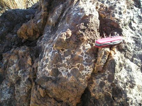
Figure 3: An example of the volcanic breccia in the Blackfella Rockhole member in the upper part of the Kalkarindji succession.
Environment before, during and after volcanism
Sediments deposited before, during and after the volcanism may provide information regarding local environment and possible environmental changes during the course of volcanic activity. Weathering horizons and intercalated sediments in the volcanic succession are signs of quiescent episodes in volcanic activity and therefore give clues to the duration of volcanism.
In general, eroded Precambrian rocks underlie the Kalkarindji basalts; however, in some areas of the Southern Victoria River Region (Northern Territory) the Kalkarindji basalts rests, possibly conformably, on a Neoproterozoic to Early Cambrian massive reddish-brown fine- to medium grained quartz sandstone. Some beds may be of aeolian origin, but there are also large areas of carbonate-rich sandstone of subaqueous origin (Sweet et al, 1974). This is quite similar to the description of the 3-5 m thick Malley Spring member (Mory and Beere, 1988), an early member of the Kalkarindji volcanics in the Ord basin on the Western Australia-Northern territory border. The Malley Spring member occurs in the lower parts of the Kalkarindji volcanic succession, and large scale cross-beds indicate some aeolian influence. In the Nutwood Downs area (Fig.1), the volcanics rests conformably on the Lower Cambrian Bukalara sandstone, and the lava appears to have erupted before the sandstone was lithified (Bultitude, 1976). The environment during the earliest volcanic activity was continental, either near-shore marine, shore-line with dunes, or fluvial with minor lacustrine and aeolian influences (Sweet et al, 1974).
There are a number of areas where layers of intercalated sediments and pyroclastics have been found; these are best described by Sweet et al (1974). Most of these interbeds are thin and of limited extent and occur at variable stratigraphic horizons. The intercalated sandstone and siltstone were deposited under subaqueous conditions (Sweet et al, 1974). In the Ord basin, there is a conspicuous, ca 5 m thick layer of chert, breccia and stromatolites (Conophyton) named the Mount Close Chert Member (Mory and Beere, 1988). This indicates an episode of paucity of volcanic activity, apparently about halfway up the succession. A number of chert beds have also been described by Sweet et al (1974, and references therein). The Blackfella Rockhole member in the upper part of the succession also contains some thin lenses of sandstone and siltstone.
In all areas early Middle Cambrian shallow-water sediments overlie the volcanics. In the East Kimberley area the Kalkarindji volcanics are overlain by Middle Cambrian Headleys limestone; the contact is a disconformity, i.e. it is concordant and possibly conformable (Mory and Beere, 1988) but there was an episode of weathering and erosion before limestone deposition (Sweet et al, 1974; Bultitude, 1976). Headleys limestone contains simple, non-branching stromatolites and is the basal unit of the Negri subgroup of the Goose Hole Group which was deposited in intertidal to shallow subtidal environments (Mory and Beere, 1974). In the Georgina basin, carbonate banks and channels with anoxic to dysoxic black sediments developed during the first flooding of the basin; one example is the early Middle Cambrian Gum Ridge formation which overlies the Helen Springs Volcanics (Freeman et al, 1990). The Gum Ridge formation is overlain by phosphorites of the Wonarah beds, and in the Eastern part of Georgina basin, the phosphatic Burton beds overlies the Peaker Piker volcanics. These deposits mark the start of the Middle Cambrian phosphogenesis in the Georgina basin related to a global sea-level rise and flooding of the North Australian craton (Freeman et al, 1990).
In summary, before and during early volcanism the landscape was continental, with lacustrine, fluvial or near shore marine sandstone deposition, partly subaerial with sand dunes. During volcanism, shallow water environment appears to have developed in different, transient localities. At the end of the volcanic activity, the basalt pile was subaerial and affected by weathering and limited erosion. Flooding of the weathered surface then occurred with deposition of carbonates in a shallow marine dysoxic anoxic to environment.
The late early Cambrian mass extinction
As mentioned previously, the mass extinction near the end of the early Cambrian affected the reefs worldwide. The reefs were dominated by archeocyaths, of which none remained in the middle Cambrian. It took some forty million years before metazoan reefs had recovered from this blow; meanwhile, microbes took over the main reef-building process (Rowland and Hicks, 2004). This extinction is thought to have occurred in two steps; the first is related to the anoxic Sinsk event in the mid-Botomian and the second is the Toyonian Hawke Bay regression (Zhuravlev and Wood, 1996). Although the Siberian stages are commonly used for the Early Cambrian, it is wise to keep in mind that officially, there is no internationally recognised stages in the Early Cambrian, due to uncertainties in the intercontinental correlations. In any case, it appears as if any explanation on how these drastic environmental changes may have been linked to the eruption of the Kalkarindji LIP will involve anoxic oceans and/or regression.
Conclusion
The Kalkarindji Continental Flood Basalt Province in northern Australia erupted around the time of the late Early Cambrian mass extinction of Archeocyath-reefs, as well as trilobites and other reef-dwellers. This link is currently being investigated with the aim of estimating the environmental impact of the Kalkarindji LIP.
On-going and planned work include:
- Ar-Ar dating of the the Table Hill Volcanics in the Officer basin, Western Australia, geochemically similar to Kalkarindji basalts.
- Investigations regarding a link between the Kalkarindji province and S-isotopes of the Middle Cambrian ocean.
- Establishment of the origin and significance of the breccia in the Blackfella Rockhole member of the Kalkarindji volcanics.
- Determination of volatile components of the Kalkarindji magmas from fluid inclusions and melt inclusions.
Acknowledgments
This research is supported by a Marie Curie International Fellowship within the 6th European Community Framework Programme.
References
Buick, I.S., Miller, J.A., Williams, I.S., and Cartwright, I. (2001) Ordovician high-grade metamorphism of a newly recognised late Neoproterozoic terrane in the northern Harts Range, central Australia. Journal of Metamorphic Geology 19, 373-394.
Buick, I.S., Hand, M., Williams, I.S., Mawby, J., Miller,,J.A and Nicoll, R.S. (2005) Detrital zircon provenance constraints on the evolution of the Harts Range Metamorphic Complex (central Australia): links to the Centralian Superbasin. Journal of the Geological Society, London. 162, 777-787.
Bryan, S.E., Riley, T.R., Jerram, D.A., Stephens, C.J. and Leat, P.T. (2002) Silicic volcanism: an undervalued component of large igneous provinces and volcanic rifted margins. In: (Eds) Menzies, M.A., Klemperer, S.L., Ebinger, C.J. and Baker, J.Volcanic Rifted Margins. Boulder, Co., Geological Society of America Special Paper 362, p 97-118.
Bultitude, R.J. (1976) Flood basalts of probable early Cambrian age in northern Australia, in Johnson, R.W., ed., Volcanism in Australasia.: New York, N.Y., United States, Elsevier Sci. Publ. Co., p. 1-20.
Campbell, I.H.; Griffiths, R.W. (1990) Implications of mantle plume structure for the evolution of flood basalts Earth and Planetary Science Letters 99, 79-93
Chen, Y.D. and Liu, S.F. (1996) Precise U-Pb zircon dating of a post-D2 metadolerite: constraints or rapid tectonic development of the southern Adelaide Fold Belt during the Cambrian. Journal of the Geological Society, London. 153, 83-90.
Christie-Blick, N. (2001) Discussion on mantle plume uplift in the sedimentary record: origin of kilometer-deep canyons within late Neoproterozoic successions, South Australia. Journal of the Geological Society, London, 158, 573-576
Courtillot, V.E. and Renne, P.R.(2003) On the ages of flood basalt events. Comptes Rendus - Academie des sciences. Geoscience 335, 113-140
Eldholm, O. and Coffin, M.F. (2000) Large Igneous Provinces and Plate Tectonics. In The history and dynamics of global plate motions. Geophysical Monograph (2000), 121 309-326
Ernst, R. E. and Buchan, K.L. (2003) Recognizing mantle plumes in the geological record. Annual Review of Earth and Planetary Sciences. 31, 469-523.
Freeman, M.J., Shergold, J.H., Morris, D.G. and Walter, M.R. (1990) Late Proterozoic and Paleozoic basins of Central and Northern Australia – Regional geology and mineralization. In (Ed Hughes, F.E.) Geology of the Mineral Deposits of Australia and Papua New Guinea. The Australian Institute of Mining and Metallurgy, Melbourne. pp. 1125-1133.
Glass, L.M., 2002, Petrogenesis and Geochronology of the North Australian Kalkarinji Low-Ti Continental Flood Basalt Province: PhD thesis, Canberra, Australian National University
Glass, L.M., Bennett, V.C. and Phillips, D.(2004) A new flood basalt province from Northern Australia: Geochronology and petrogenesis of the Cambrian Kalkarindji low-Ti basalts. Abstract, 14th Annual Goldschmidt conference 5 to 11 June 2004. Geochimica et Cosmochimica Acta 68 (11), Supplement 1, A585.
Gole, M. (2001) Table Hill Volcanics. Geochemistry of mafic rocks from petroleum wells Akubra 1, Boondawari 1, Yowalga 2 and Empress 1A and a surface sample. GSWA sampling approval No. S311557. Unpublished report, Ausquest Ltd.
Gole, M. and Thornett, J. (2003) Geochemistry of rocks from petroleum wells Akubra 1, Boondawari 1 and Mundadjini 1. GSWA sampling approval No. S31557. Unpublished report, Ausquest Ltd.
Haines, PW, Hand, M. and Sandiford, M. (2001) Palaeozoic synorogenic sedimentation in central and northern Australia; a review of distribution and timing with implications for the evolution of intracontinental orogens. Australian Journal of Earth Sciences 48(6):911-928
Hanley, L.M., and Wingate, M.T.D. (2000) SHRIMP zircon age for an Early Cambrian dolerite dyke: an intrusive phase of the Antrim Plateau Volcanics of northern Australia: Australian Journal of Earth Sciences, v. 47, p. 1029-1040.
Hill, R.I. (1991) Starting plumes and continental break-up. Earth and Planetary Science Letters 104, 398-416.
Holser, W.T.(1977) Catastrophic chemical events in the history of the ocean. Nature, 267, 403-408.
Kump, L.R., Pavlov, A. and Arthr, M.A. (2005) Massive release of hydrogen sulfide to the surface ocean and atmosphere during intervals of oceanic anoxia. Geology 33, 397-400.
Kurtz, A.C.., Kump, L.R., Arthur, M.A., Zachos, J.C. and Payton, A. (2003) Early Cenozoic decoupling of the global carbon and sulfur cycles. Paleoceanography 18 (4), 1090, doi: 10.1029/2003PA000908, 2003
Macdonald, F. A., Wingate, M. T. D., Mitchell, K.(2005) Geology and age of the Glikson impact structure, Western Australia. Australian Journal of Earth Sciences, Volume 52, Numbers 4-5, -5/2005, pp. 641-651
McElwain, J.C. , Wade-Murphy, J. and Hesselbo, S.P (2005) Changes in carbon dioxide during an anoxic event linked to intrusion into Gondwana coals. Nature, 435, 479-482
Montañez, I.P., Osleger, D.A., Banner, J.L. Mack, L.E. and Musgrove, M. (2000) Evolution of Sr and C isotope composition of Cambrian Oceans. GSA Today 10 (5), 1-7.
Mory A. J. and Beere G. M. (1988) Geology of the onshore Bonaparte and Ord basins in Western Australia. Geological Survey of Western Australia Bulletin 134.
Pisarevsky, S.A., Li, Z.X., Grey, K. and Stevens, M.K. (2001) A paleomagnetic study of Empress 1A, a stratigraphic drillhole in the Officer basin: evidence for a low-latitude position of Australia in the Neoproterozoic. Precambrian Research 110, 93-108.
Ross, P.-S., Ukstins Peate, I., McClintock, M.K., Xu, Y.G., Skilling, I.P., White, J.D.L., Houghton, B.F. (2005) Mafic volcaniclastic deposits in flood basalt provinces: a review. Journal of Volcanology and Geothermal Research 145, 281-314.
Rowland, S.M. and Hicks, M. (2994) The Early Cambrian experiment in reef-building by metazoans. In (Eds. Lipps, J.H and Waggoner, B.M.) Neoproterozoic-Cambrian Bilogical revolutions. The Paleontological Society Papers 10, p 107-129.
Shields, G. and Evins, L. (2004) Mass Extinctions Caused by Australian Volcanism. Australasian Science 25 (4), 14-18.
Sigurdsson H. (1990) Assessment of the atmospheric impact of volcanic eruptions. In Global catastrophes in Earth history; an interdisciplinary conference on impacts, volcanism, and mass mortality, (ed. V. L. Sharpton and P. D. Ward), pp. 99-110. Geological Society of America Special Paper Vol. 247.
Sweet, I. P.; Mendum, J. R.; Bultitude, R. J., and Morgan, C.M. (1974). The Geology of the Southern Victoria River Region, Northern Territory. Bureau of Mineral Resources Report , Geology and Geophysics 167. Canberra, A.C.T. Australian Geological Survey Organisation
Walter, M.R., Veevers, J.J., Calver, C.R. and Grey, K. (1995) Neoproterozoic stratigraphy of the Centralian Superbasin, Australia. Precambrian Research 73, 173-195.
Williams, G.E and Gostin, V.A. (2000) Mantle plume uplift in the sedimentary record: origin of kilometer-deep canyons within late Neoproterozoic successions, South Australia. Journal of the Geological Society, London, 157, 759-768
Zhuravlev, A.Y., and Wood, R.A., 1996, Anoxia as the cause of the mid-Early Cambrian (Botomian) extinction event: Geology (Boulder), v. 24, p. 311-314