September 2013 LIP of the Month
A review of Kalkarindji - the oldest Phanerozoic flood basalt province
Peter Marshall and Mike Widdowson
University Lecturer in Volcanology, Department of Environment, Earth and Ecology, The Open University, Walton Hall, Milton Keynes MK7 6AA
email: m.widdowson@open.ac.uk; peter.marshall@open.ac.uk
Luke Faggetter
School of Earth & Environment, University of Leeds, Leeds, LS2 9JT U.K.
email: lukefaggetter@hotmail.co.uk
Note also earlier LIP of the Months on the Kalarindji LIP:
October 2005: http://www.largeigneousprovinces.org/05oct
October 2006: http://www.largeigneousprovinces.org/06oct
October 2010 (review of Australian LIPs) http://www.largeigneousprovinces.org/10oct
The Kalkarindji continental flood basalt province (CFBP) of northern Australia is one of the lesser known large igneous provinces (LIPs) in the world. At 505 - 510 Ma (Glass & Phillips, 2006) it is the oldest known CFBP to have been erupted during the Phanerozoic. Investigation of the extent, age, structure volcanology and chronology of the province remains at an early reconnaissance stage. In Northern Territory the basalts are little deformed and the original volcanology and petrology are exceptionally well preserved, despite their age.
What today is known as the Kalkarindji province actually comprises five individual volcanic sub-provinces spread across Northern Territory (NT), Northwestern Queensland (Qld) and Western Australia (WA) with a potential feeder dyke, also in WA (fig. 1). If the current outcrops in these sub-provinces were originally part of a continuous CFBP, then arguably they would have had a considerable pre-erosive extent, and an inferred minimum eruptive volume of 1.5 ϰ 105 km3, similar to that of the well preserved Columbia River Basalt Province, USA. However, since each sub-province corresponds to a different pre-existing depo-basin it is possible that each sub-province may have been geographically independent of one another, and that each was fed by its individual system of volcanic centres. If this is the case, then significant differences in volcanic architecture and differing syn-volcanic palaeo-environments might be expected. On the other hand, the age and geochemistry of the extrusive successions of each sub-province are sufficiently closely related to suggest they are linked a single regional volcanic event.
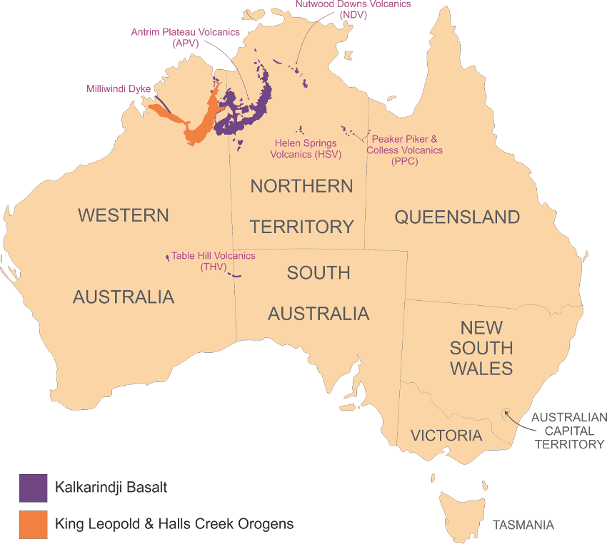
Figure 1: Map of Australia displaying the modern day outcrop of the basalts of Kalkarindji.
Hardman (1885) originally named the basaltic hills east of the Elvire River as the ‘Great Antrim Plateau’, and in doing so was probably drawing attention to similarities between the Australian examples and the basaltic successions of Antrim, Northern Ireland. However, it wasn’t until David (1932) and later Traves (1955) that the Antrim Plateau Volcanics became better known, and were described as extensive basaltic successions in the Ord-Victoria River Region. The Antrim Plateau Volcanics (APV), is now recognised as the most extensive of the Kalkarindji CFBP sub-provinces, forming a semi-continuous outcrop over c. 40,000 km2 in the Victoria River and East Kimberley Regions of Northern Territory and Western Australia. Tilted sections in the East Kimberley indicate it has a maximum,thicknesses of 0.2 - 1.1 km (Mory & Beere, 1985), with much thinner successions preserved to the east (Cutovinos et al., 2002).
Detailed mapping of the area first occurred in the 1970s (Bultitude, 1971; McElhinny & Luck, 1970; Sweet et al., 1971, 1974a, 1974b). The APV volcanic succession consists of mainly undifferentiated basaltic flow units, occasionally and patchily interspersed with arenaceous and chertified sedimentary units; only 4 readily recognizable units are readily distinguishable in the field (Mory & Beere, 1985). These are the Blackfella Rockhole Member (a laterally-extensive, thick volcanic breccia succession), the Bingy Bingy Basalt Member (a prominent flow field consisting of plagioclase-phyric basalt, and commonly displaying notable brownish weathering and well-developed jointing), the Mt. Close Chert Member (a locally developed sedimentary unit consisting of chertified stromatolite bioherms), and the Malley Spring Sandstone Member.
Located to the west of the APV, in the Kimberley region of Western Australia (17°7’S 125°11’E), is the Milliwindi dyke. This linear shaped dolerite outcrops for ~250km striking NW-SE, cutting across Protopalaeozoic units of the King Leopold orogenic belt at Lennard River (Griffin et al., 1993). This dyke, and other related dolerites in the area, is geochemically indistinguishable from the basalts of the APV. Hanley and Wingate (2000) therefore inferred that these outcrops may be part of a wider dyke swarm, potentially extending as far as Halls Creek to the south (a total distance of ~300 km from coast to Mount Ramsay); if so, these could represent part of a feeder system for the whole Kalkarindji province.
To the east of the APV lie the three satellite provinces of Nutwood Downs Volcanics (NDV), Helen Springs Volcanics (HSV) and the Peaker Piker and Colless Volcanics (PPC). These minor outcrops of basalt were originally mapped as individual expressions of lava by Bultitude (1972). Whilst it has long been suggested that these sub-provinces are likely of similar age to the APV and thus linked, it wasn’t until Glass (2002) that this was confirmed by the matching of chemical signatures. Importantly, Glass also provided the first successful 40Ar/39Ar dating of samples from the HSV and APV which dated the province at 505 - 510 Ma, and further confirming the relationship between the APV and its sub-provinces as being coeval, and part of the same eruptive succession. It was Glass who suggested that the CFBP in its entirety be given the name Kalkarindji – after an aboriginal settlement (17°26′0″S, 130°50′0″E) that lies in the south of the main APV area.
The Table Hill Volcanics (THV) in Western Australia are considered by Glass (2002) and subsequently Evins (2009) as part of the same volcanic expression through geochemical correlation and in stratigraphic relationships by Grey et al. (2005). Situated on the edges of the Officer basin, they lie >1,250 km to the south-west of the APV, outcropping as small basaltic successions covering a similar area as the Peaker Piker volcanics. They are considered synonymous with the Kulyong Volcanics in South Australia (Townsend, 1985). The full extent of these volcanics has been speculated to exceed 90,000 km2 due to correlation with subsurface intrusives found in the Savory sub-basin (NW officer basin; Townsend, 1985). In type section the volcanics are 26 m thick with a maximum thickness reported at 118 m (Townsend, 1985).
Volcanology
Much of the APV succession (including that material retrieved from boreholes), consists of flow units of 15 – 25 m thickness. These are typical of pahoehoe inflation units common in CFBP successions elsewhere. These consist of sharp, well-defined bases, fine-grained, vesicle-poor cores, and a moderately- to highly-vesiculated crustal zone. Crude columnar jointing and entabulature is only rarely developed. Post-eruptive weathering has obliterated many of the finer features, but ropey pahoehoe surfaces are preserved on some flow tops, together with evidence of squeeze-outs and, where exhumed by erosion, tumuli-like features may be observed disrupting in the lava crust.
Towards the top of the main APV basalt succession, and in places directly underlying the Headleys and Montejinni Limestones, lies the c. 30 – 50 m thick Blackfella Rockhole Member (BRM). This member was first identified by Sweet et al. (1974) and its description was amended by Mory & Beere (1976 & 1988). It has been shown to outcrop predominately to the south of the Ord Basin in the SW of the APV, and similar occurrences are noted to the North and East of the province, thus suggesting it was once much more extensive. Mory and Beere (1976) describe the BRM as a ‘basaltic agglomerate’, and it appears as such on many map and stratigraphic databases. This definition has led to searches for vent locations within the province in the belief that this basaltic agglomerate is of tuffaceous origin and this indicative of proximity to eruptive sites. However, Mory and Beere (1976) also describe abrupt upper contacts and gradational lower contacts within the agglomerate succession; these observations may indicate that the agglomerate layer represents the upper part of single lava flows.
Geochemically, all the lavas display a similar evolved signature of a basaltic andesite as the undifferentiated flows seen elsewhere in the province. Further, on the basis of its thickness, regularity of composition, and geographical extent, the BRM may deserve upgrading from a ‘basaltic member’ to that of a recognisable formation within the APV sub-region of the Kalkarindji CFBP.
Basalt Petrogenesis
Glass (2002) reported that the Kalkarindji basalts have an enriched trace element signature resembling continental crust and show marked Nd and Sr isotopic enrichment, i.e. initial 87Sr/86Sr typically varies within a restricted range from 0.707 to 0.709. Initial ɛNd values typically cluster in a narrow range between -3.0 and -4.5.
Crystal fractionation was the dominant process responsible for the chemical evolution of basalts containing between c. 3 - 9 wt% MgO. However, subtle up-stratigraphic variations in crust-sensitive trace element ratios (e.g. Ba/Rb, Nb/U, Nb/Ta and Th/U), are associated with shifts in isotopic ratios suggesting involvement of minor, but measurable high-level crustal contamination. However, the isotopic compositions and key crust-sensitive trace element ratios do not appear to correlate with indices of fractionation because 87Sr/86Sr, δ18O and Ba/Rb show negligible variation over a range of Mg#, indicating that the crust-like signature of the Kalkarindji basalts was acquired at compositions more primitive than 9 wt% MgO.
One of the most distinctive features of this CFBP (and many other low-Ti CFBPs) is the relative depletion of the HFSE, notably Ti, P and Nb. In addition, the Kalkarindji basalts are significantly enriched in Th and U, and have the most extreme Th/U ratios observed for any flood basalt province; these features are compatible with a contamination overprint by Proterozoic North Australian felsic crust.
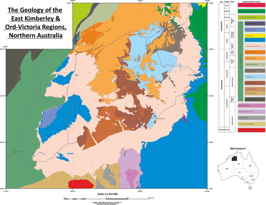
Figure 2: Summary map of the geological units around the Antrim Plateau Volcanics (pink) in the East Kimberley and Ord-Victoria region (see below).
Stratigraphical Setting of the APV
The APV unconformably overlies a series of Proterozoic sediments and is in turn overlain unconformably by sediments of Cambrian age. Bounding the western edge of the APV is the Halls Creek Orogen. This is a complex series of faults and thrusts containing units ranging from the Palaeoproterozoic through to the Devonian.
Pre-eruptive Basements:
The history of the craton, pre-eruption, stretches back to around 2.5 Ga with the beginnings of the Tanami Orogeny located to the south of Kalkarindji in what today is known as the Tanami desert or the ‘red centre’ of Australia. Through the Proterozoic there have been 4 sedimentary basins preserved in the stratigraphy around Kalkarindji. The oldest of these is the Kimberley basin, stretching from the Kimberley Craton eastwards towards the Halls Creek Mobile Zone. Deposited during the Palaeoproterozoic around 1800 Ma, the group is predominately quartz sandstones, with minor fine- to medium-grained feldspathic sandstones. The Kimberley basin is separated from the main undeformed APV sequence, but can be found directly underlying fragments of Cambrian basalt within the Halls Creek Orogen.
The oldest sediments to directly underpin the APV are those of the Birrindudu basin in the Mesoproterozoic with a maximum age of 1780 Ma, depositing until 1350 Ma. This basin stretches from the Tanami in the south (Birrindudu Group) northwards to the Victoria River with outcrops of the Tijunna Group uncovered by downcutting of the river (fig. 2). These sediments are primarily sublithic arenites, dolostones, siltstones and undeformed sandstones.
Unconformably overlying the Tijunna group are the conglomeratic sandstones, siltstones and shales of the Auvergne Group which were deposited between 810 Ma and 750 Ma. These sediments also unconformably overlie the sandstones of the Fitzmaurice Group (1250 Ma - 1150 Ma). The Auvergne and Fitzmaurice groups make up the Meso- to Neo-proterozoic Victoria basin. Following this, a hiatus of ~100 Ma is lost from the stratigraphic record, leaving an unconformity between the Victoria basin and the overlying Duerdin Group of the Neoproterozoic Wolfe basin. These sandstones, conglomerates and minor diamictites were deposited over a 50 Myr period between 650 Ma - 600 Ma.
Post-eruptive succession and associated palaeo-environments:
In the East Kimberley and western Ord-Victoria Region, the CFBP succession is capped by the Headleys Limestone. The basalt is overlain in the east by the Montejinni Limestone and Tindall Limestone to the north. These stromatolitic limestones were formed individually in three distinct basins (Ord, Wiso and Daly respectively), yet their similarities suggest that the processes which formed them were consistent throughout the separate basins in which they reside. The Headleys-Montejinni-Tindall succession represents a period of stable, marine-like conditions resulting from inundation of the lava fields. It remains unclear whether there is a major disconformity between the final APV eruptions, and the onset of this stromatolite development. Overlying the Montejinni and Tindall limestones is a large swathe of undifferentiated Cretaceous sediments of the Carpentaria Basin. The Headleys Limestones however underlie a more complex series of sediments.
The Ord basin has been geographically constrained as a region of deposition south of the Bonaparte Basin (Mcwhae et al., 1958), spanning the border between Western Australia and the Northern Territory (Kruse et al., 2004). It contains a succession of depositional units including and overlying the APV sub-region of the Kalkarindji CFBP. The basin succession contains three major subdivisions; in ascending order these are: the middle Cambrian Antrim Plateau Volcanics (APV) Goose Hole Group and the Mahony Group (Mory & Beere, 1985). The post-APV Goose Hole Group contains two sedimentary Subgroups; (i) Negri Subgroup which consists of a conformable succession of Headleys Limestone, Nelson Shale, Linnekar Limestone, and Panton Formation (incl. undivided shales and the Shady Camp and Corby Limestones); (ii) Elder Subgroup consisting of the Eagle Hawk and Overland Sandstone units (Kruse et al, 2004).
(i) The Negri Subgroup
The basal unit of the Negri Subgroup is, the Headleys Limestone. Bultitude (1971) reported that the Headleys Limestone disconformably overlies the APV, although a more recent study (Kruse et al., 2004) suggests that the transition between the APV and the Headleys Limestone is conformable. The precise stratigraphic relationship between the volcanics and limestone remains poorly understood; but it likely represents a hiatus of unknown duration between cessation of the Kalkarindji LIP eruptions and the onset of an extensive marine transgression; the latter ultimately leading to the flooding of a significant area of the North Australian Craton. Accordingly, these sedimentary units, record the palaeoenvironments immediately subsequent to cessation of the period of CFBP eruption.
The limestones are typically massive, grey laminated units reaching a maximum thicknesses of 50 m (Kruse et al., 2004). Contact with the underlying APV typically shows ferruginisation and silicification of the basalts relating either to pre-depositional weathering, and/or modification by recent processes (Cutovinos et al., 2002; Mory & Beere, 1985). At the base of the formation ovoid and flat siliceous nodules typify the bedding planes and adjacently compressed stomatolitic laminae suggest the chert nodules may be of early diagenetic origin, most likely evaporates. The lower half of the unit as a whole commonly contains regular shaped chert nodules spread within the evenly laminated micritic/stromatolitic limestone. The upper section is largely comprised of thinly bedded, wrinnkled limestone representing remnants of microbial biofilms. The limestone units become marly toward the top and pass conformably into the overlying Nelson shales (c. 100 - 150 m thick); these are maroon-grey shales, siltstones and minor, very fine-grained arkosic sandstones (Mory & Beere, 1985; Kruse et al., 2004). Whilst the Nelson Shale succession contains few fossiliferous remains, it does include the Linnekar limestone - a microbially mediated laminite, (Kruse et al., 2004) consisting of thickly bedded to massive stromatolitic laminae, including bedding-parallel siliceous nodules (Mory & Beere, 1985).
The Panton Formation and its two named members (Shady Camp Limestone and Corby Limestone) conformably overlie the Linnekar Limestone, and at its maximum reaches thicknesses of 308 m (Kruse et al., 2004). The formation is for the most part unfossiliferous maroon-purple gypsiferous shale-mudstone, however, the two limestone members contain a wealth of mid to late Cambrian fossil material.
(ii) The Elder Subgroup
The uppermost unit in the Goose Hole Group is c. 400 m of predominantly marine to fluviatile sandstones beginning with the Eagle Hawk Sandstone - a fine to medium micaceous and feldspathic sandstone contaning minor siltstone and mudstones; this is overlain by the Overland Sandstone - a white, fine to medium lithic arkose and sandstone.
The Mahony Group
Overlying the Cambrian Goose Hole Group sediments are the famous Bungle Bungle formations of the Mahony Group. These Devonian age quartz sandstones are world renowned for their beehive structures and distinctly marked horizontal bands of dark-grey cyanobacterial crust. These structures hold great significance to the local Aboriginal communities of the Gidja and Jaru peoples. The Purnululu National Park in which they reside is a UNESCO Heritage site.
References
Bultitude, R. . (1971). The Antrim Plateau Volcanics, Victoria River District, Northern Territory. Bureau of Mineral Resources, Geology and Geophysics, 1971/69.
Bultitude, R. J. (1972). The Geology and Petrology of the Helen Springs, Nutwood Downs, and Peaker Piker Volcanics. Bureau of Mineral Resources, Geology and Geophysics, 1972/74.
Cutovinos, A., Beier, P., Kruse, P., Abbot, S., Dunster, J., Brescianini, R., & Beier, P., Kruse, P., Abbot, S., Dunster, J., & Brescianini, R. (2002). Limbunya, Northern Territory (Second Edition), 1:250 000 geological map series and explanatory notes, SE 52-07. Darwin.
David, T. W. E. (1932). No Explanatory notes to accompany a new geological map of the Commonwealth of Australia. Australia Council for Scientific and Industrial Research, Sydney.
Evins, L. Z., Jourdan, F., & Phillips, D. (2009). The Cambrian Kalkarindji Large Igneous Province: Extent and characteristics based on new 40Ar/39Ar and geochemical data. Lithos, 110(1-4), 294–304.
Grey, K., Hocking, R.M., Stevens, M.K., Bagas, L., Carlsen, G.M., Irimies, F., Pirajno, F., Haines, P.W., Apak, S.N. (2005). Lithostratigraphic nomenclature of the Officer Basin and correlative parts of the Paterson Orogen.Western Australia Geological Survey of Western Australia, Report, vol. 93. 95 pp.
Glass, L. M. (2002). Petrogenesis and Geochronology of the North Australian Kalkarinji Low-Ti Continental Flood Basalt Province. PhD Thesis - Australian National University.
Glass, L. M., & Phillips, D. (2006). The Kalkarindji continental flood basalt province: A new Cambrian large igneous province in Australia with possible links to faunal extinctions. Geology, 34(6), 461–464.
Griffin, T. J., Tyler, I. M., & Playford, P. E. (1993). Lennard River Sheet SE/51-8, 1:250 000 Geological Series. Perth.
Hanley, L. M., & Wingate, M. T. D. (2000). SHRIMP zircon age for an Early Cambrian dolerite dyke: An intrusive phase of the Antrim Plateau Volcanics of northern Australia. Australian Journal of Earth Sciences, 47(6), 1029–1040.
Hardman, E. T. (1885). Report on the geology of the Kimberely District, Western Australia. West Australian Parlimentary Paper No 34.
Kruse, P.D., Laurie, J.R. & Webby, B.D. (2004). Cambrian geology and palaeontology of the Ord Basin. Memoirs of the Association of Australasian Palaeontologists 30, 1-58.
McElhinny, M. W., & Luck, G. R. (1970). The Palaeomagnetism of the Antrim Plateau Volcanics of Northern Australia. Geophysical Journal of the Royal Astronomical Society, 20, 191–205.
McWhae, J. R. H., Playford, P. E., Linder, A. W., Glcnister, B. F. & Balme, B. E. (1958). The stratigraphy of Western Australia: Geol. Soc. Australia Jour., v.4 pt 2.
Mory, A. J., & Beere, G. M. (1985). Palaeozoic Stratigraphy of the Ord Basin, Western Australia and Northern Territory. Geological Survey of Western Australia Article, 14, 36–45.
Mory, A. J., & Beere, G. M. (1988). Geology of the Onshore Bonaparte and Ord Basins in Western Australia. Geological Survey of Western Australia Bulletin, 134.
Sweet, I. P., Mendum, J. R., Bultitude, R. J., & Morgan, C. M. (1971). The Geology of the Waterloo, Victoria River Downs, Limbunya and Wave Hill 1:250,000 Sheet Areas, Northern Territory. Canberra.
Sweet, I. P., Mendum, J. R., Bultitude, R. J., & Morgan, C. M. (1974). The Geology of the Southern Victoria River Region, Northern Territory. Bureau of Mineral Resources, Geology and Geophysics, Report 167.
Sweet, I. P., Mendum, J. R., Morgan, C. M., & Pontifex, I. R. (1974). The Geology of the Northern Victoria River Region, Northern Territory. Bureau of Mineral Resources, Geology and Geophysics, Report 166.
Townson,W.G. (1985). The subsurface geology of the western Officer Basin — results of Shell's 1980–1984 petroleum exploration campaign. APEA Journal 25, 34–51.
Traves, D. M. (1955). The Geology of the Ord-Victoria Region, Northern Australia. Bureau of Mineral Resources, Geology and Geophysics Bulletin, 27.