May 2015 LIP of the Month
Eruption environment of the Emeishan Large Igneous Provinces and re-evaluation on the mantle plume-induced crustal uplift
Bei Zhu1, Ingrid Ukstins Peate2
School of Earth and Space Sciences, Peking University, Beijing, China
Department of Earth and Environmental Sciences, University of Iowa, IA, USA
Introduction
The Emeishan large igneous province (ELIP) is located in Southwest China with an extant area of about 0.25×10⁵ km2 (e.g. Ali et al., 2005) (Fig.1). It is composed of mainly flood basalts (i.e. the ‘Emeishan Basalts’ frequently referred to in the Chinese literature), associated with mafic and felsic intrusive complexes, picrites, rhyolites, ignimbrites and newly discovered varieties of hydroclastic deposits. Geochronological dating shows that the ELIP was formed at ~260 Ma (see summary by Shellnut, 2014), coincident with the End-Guadalupian mass extinction (Wignall, 2001; Wignall et al., 2009). Stratigraphically, the ELIP succeeds the Maokou Formation, a limestone platform formation spread over the entire Yangtze plate during the Guadalupian Epoch. Based on the rapidly evolving fusulinid records, the Maokou Formation can be subdivided into three bio-stratigraphic units: Neoschwagerina Simplex zone at the lower, followed by Neoschwagerina Craticulifera-Afghanella schencki zone in between, and a Neomisellina-Yabeina zone at the upper (He et al., 2003, Isozaki et al., 2008; Sun et al., 2010; Shen et al., 2013). Previous workers estimated the thickness of the Maokou formation across the whole ELIP and found that it generally shows a concentric thinning pattern from the edge to the center of the ELIP, making the three fusulinid zones gradually absent downward (He et al., 2003). Since previous physical-numerical simulation on mantle plume dynamics had predicted that mantle plume upwelling would cause significant crustal uplift before the emplacement of the LIP (e.g. Griffith and Campbell, 1991; Farnetani and Richards, 1994), and sedimentary records in other LIPs has also shown supportive evidence for this model (Rainbird and Ernst, 2001), He et al., (2003) consequently concluded that the thinning phenomenon of the Maokou Formation was due to severe erosion caused by a similar crustal uplift dynamics of the Emeishan mantle plume. Following this interpretation, the ELIP was divided into three roughly concentric zones, named the inner, intermediate and outer zones representing for different degrees of uplift (Fig. 1). The subsequent volcanic materials, in this interpretation, were therefore emplaced into a totally subaerial, erosional background.
However, this view was challenged when Ukstins Peate and Bryan (2008) re-studied the ‘alluvial fan deposits’ in the intermediate zone that He et al., (2006) had interpreted as terrestrial erosion materials from the inner zone, consistent with the uplift model. These new field observations suggested that such materials are in fact varied facies of mafic hydromagmatic deposits, a lithology that is unlikely to be produced on a highly uplifted, subaerial environment, but instead in a subaqueous environment without severe crustal doming. This revision lead to a debate which attracted wide scientific interest (He et al., 2009; Ukstins Peate and Bryan, 2009; Ali et al., 2010; Leng and Zhong et al., 2010; Sun et al., 2010; He et al., 2010; He et al., 2011; Ukstins Peate et al., 2011; Wang et al., 2014; Zhu et al., 2014). Since then, more documentation on mafic hydromagmatic deposits and subaqueous eruption materials has been published, providing increasing clues for a fuller understanding of the paleoenvironment during the ELIP event (Wignall et al., 2009; Sun et al., 2010; Wang et al., 2014; Zhu et al., 2014). In this article, we provide an up-to-date summary of these published data on the Emeishan mafic hydromagmatic deposits and subaqueous volcanics, followed by a brief overview of their significance.
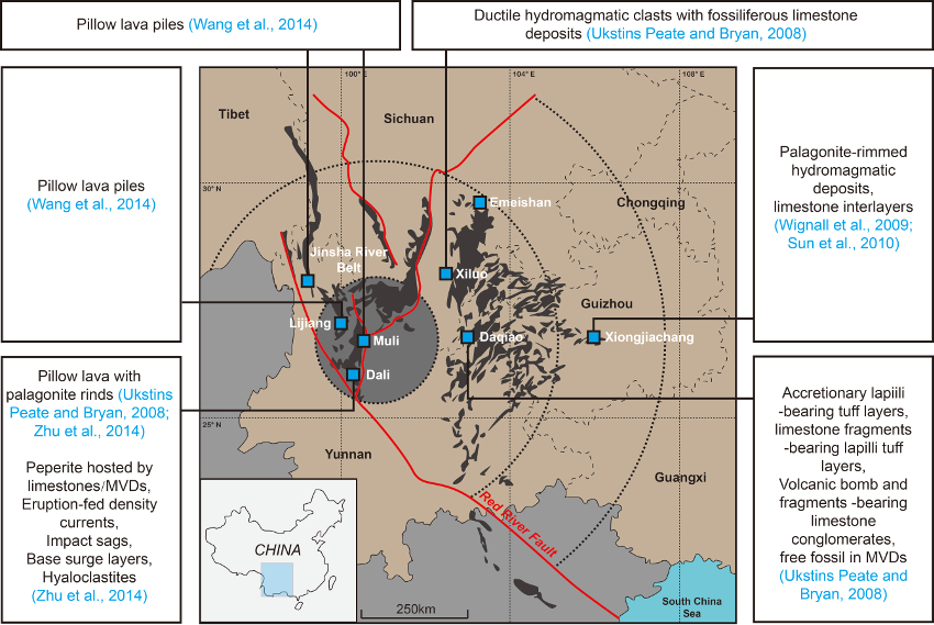
Figure 1. The distribution of the ELIP outcrops (shaded area) and localities with reported mafic hydromagmatic deposits / subaqueous environment indicators. The three concentric circles respectively represent the inner zone, the intermediate zone and the outer zone of the ELIP.
Summary of all published mafic hydromagmatic deposits and submarine eruption records in the ELIP
The presence of mafic hydromagmatic deposits has been reported widely across the inner, intermediate to outer zones of the ELIP. Most deposits are reported in the lower part of the local ELIP sequences, although in some reports, the deposits are only briefly mentioned without any detailed indication as to their stratigraphic level.
Inner zone
The ‘inner zone of the ELIP’ in the uplift view coincides with the central area related to the axis of the mantle plume, although its western flank has been destroyed by later tectonic movements related to the India-Asia collision. This central area is characterized by the greatest strata thicknesses, exclusive development of picrite and rhyolite, and the most recently reported giant dyke swarm system of the Emeishan LIP (Li et al., 2015), from which the precise extent of the plume center area was confined. This area also preserves the famous Panzhihua intrusive complex which bears a world-class V-Ti-Fe ore deposits (Zhang et al, 2009). Submarine eruption records are widely found in the inner zone (Fig. 1). They include the Shangcang shoaling section logged by Zhu et al., (2014) and pillow lava piles recently reported in Lijiang and Muli (Wang et al., 2014).
Perhaps the mostly famous volcanic section in the inner zone is the Shangcang section (sometimes called Binchuan or Dali section), which is the thickest section (over 5000m) in the whole province. Although the geological background of this section is briefly mentioned to indicate the sampling locations in many geochemistry and petrology papers, its volcanology has only recently been described in detail. Zhu et al. (2014) has summarized the general volcano-stratigraphy and subdivided it into three sub-successions, respectively named the basal, lower and upper (Fig. 2). This tri-division is mainly based on lithology, which indicates an upward shoaling process from deeper submarine to shallower submarine, and finally to subaerial flood basalt.
Basal succession: The basal succession is characterized by a stable accumulation of up to 300 m pillow lavas without any significant volcaniclastic materials infilling or intercalated (Fig. 2f). These basal pillow lavas are mainly seen in field outcrops on the east coast of Erhai Lake, Dali. Clear quenching crusts are observed around the outer edges of pillows and they are characterized by a brown palagonite component (Fig. 2f). The interspaces of the pillow lava are filled either by crystalline materials (Zhu et al., 2014) or carbonate sediments (Ukstins Peate and Bryan, 2008). Primary carbonate layers intercalated in the pillow lavas are sometimes observed in certain outcrops as well (Ukstins Peate and Bryan, 2008; Zhu et al., 2014). The relationship between the pillow lavas and the carbonate materials suggests the lavas were emplaced in an active submarine sedimentation environment (Ukstins Peate and Bryan, 2008). The lack of significant associated hydromagmatic materials implies the initial volcanism probably occurred in a deeper water depth where explosive hydrovolcanism was generally prohibited by the high water pressure (e.g. the volatile fragmentation depth, Fisher, 1984) (Zhu et al., 2014).
Lower succession: The lower succession is different from the basal pillow lava suceession, being characterized by a much greater proportion of hydroclastic deposits varied in facies (Fig. 2). Pillow and sheeted lavas are subordinate in the Lower succession. Hydroclastic features such as composite lapilli-bearing tuffs, drop debris sagging into unconsolidated stratified tuffs and non-welded, massive to graded lapilli tuff which represents an eruption-fed subaqueous density current background are widely observed in its ~2600 m stratigraphic thickness (Fig. 2e, 3a, b, c). Peperite, an precise environment-indicating volcaniclastic deposits, is also identified in the Lower successions (Fig. 2d). As they are generated from mingling of magma with unconsolidated sediments, if peperite is observed in field outcrops, then at least two deductions can be made: (a) volcanism and active sedimentaion are contemporaneous; and (b) the environment of magma/lava emplacement can be determined by the facies of host sediments. In the lower succession, two kinds of peperite are recognized: palagonite tuff-hosted peperite (Fig. 2d), and carbonate-hosted peperites (Fig. 3d). Both indicate that the volcanism was synchronous with subaqueous sedimentation, and the prevailing proportion of hydromagmatic volcaniclasts further suggest that the water depth was shallower where explosive eruptions dominated.
Upper succession: the upper succession is defined as the stratigraphic level where hydroclastic materials become totally absent and the dominant facies is subaerial flood basalts flows. This ~2000 m succession represents the main stage of the ELIP volcanism, and gives the classical impression of the Emeishan Basalts (Fig. 2b, c). Silicic rocks (ignimbrite, rhyolite) are found in the uppermost few hundred meters (Fig. 2). The weathering crust developed at the surface of the uppermost rhyolite covered by Triassic conglomerate marks the termination of the thickest sequence of the ELIP (Fig. 2a). The upper succession is interpreted to have developed when the local environment transitioned to a subaerial setting after a long time of deeper and shallower submarine eruptions. The final emergence of volcanic field was probably a consequence of the growth of the volcanic edifice rather than crustal domal uplift prior to the onset of the main ELIP event.
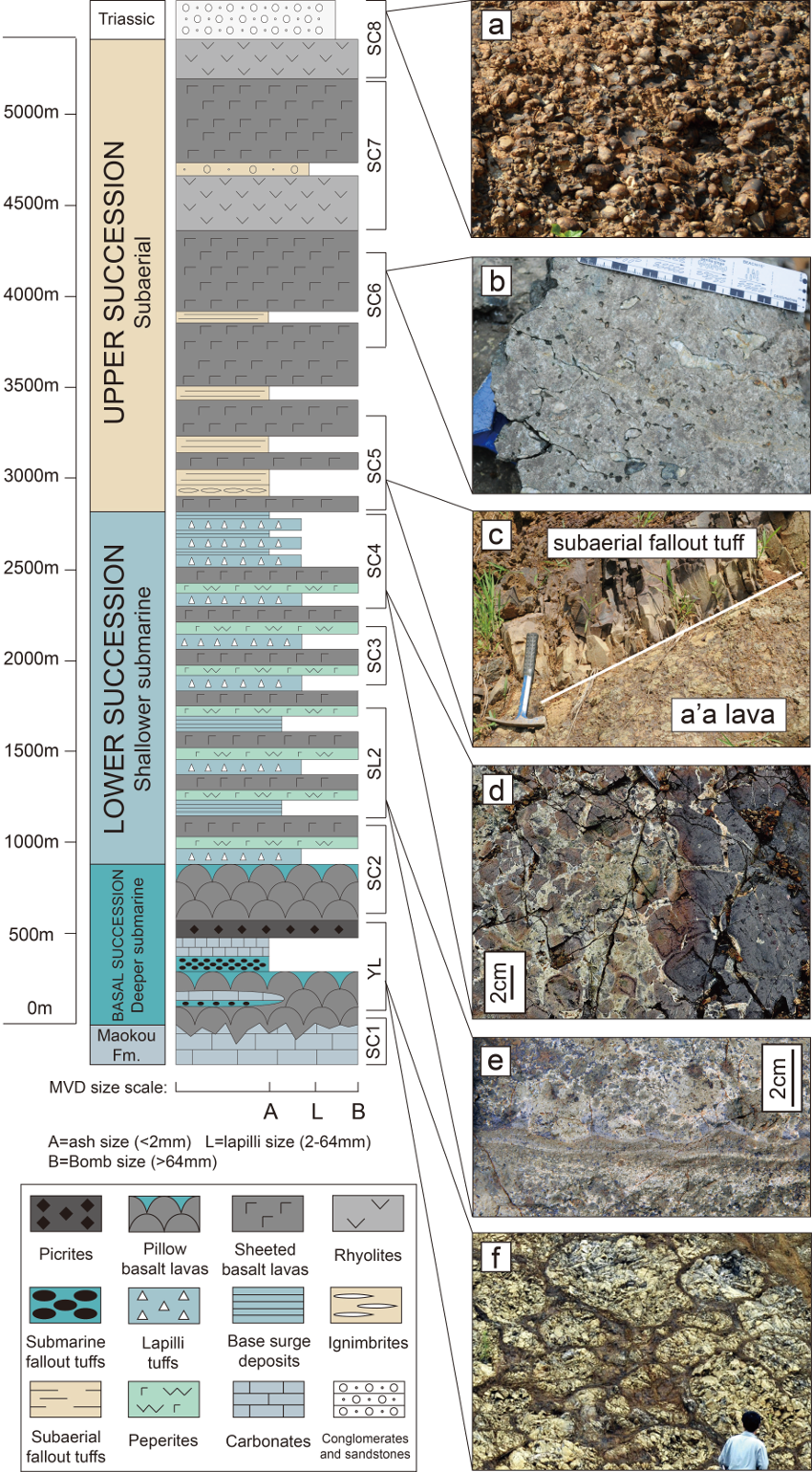
Figure 2. Abbreviated stratigraphic log of the ELIP sequences, Shangcang, Dali. (a) Triassic conglomerates directly overlying the ELIP, with their deposits derived from the erosion of underlying ELIP volcanic materials. (b) Subaerial pahoehoe lava flows with elongated vesicles showing the flow direction. (c) Red, fine-grained subaerial fallout tuffs interbedded with a’a lavas. (d) The peperitic rim of a lava body bulldozed into altered volcaniclastic deposits. Close to the magma body, compacted blocky peperites developed, with sediments filled in their jigsaw-fit textures. (e) Base surge layers showing load structures or ripple marks. (f) Pillow lavas with palagonite crusts.
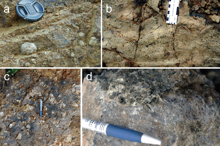
Figure 3. Field observations, Dali. a, composite lapilli supported in hydroclastic density current layers, Shangcang, Dali; b, impact volcanic breccia sagging into underlying layers, Dali; c, non-welded lapilli tuff layer with blocky breccia and palagonite materials, indicating a hydroclastic density current origin, Dali; d, Maokou limestone hosted peperite, Dali.
Intermediate zone
The most detailed section studied in the intermediate zone is probably the Daqiao section, which contains piles of MHDs generally distributed in its lower level (Ukstins Peate and Bryan, 2008; Wang et al., 2014). This MHD sequence was once interpreted as ‘alluvial fan wedge’ derived from erosion of materials from the inner zone, the inferred maximum uplifted area, but now it is re-interpreted as hydromagmatic MVD layers (Ukstins Peate and Bryan, 2008). Three distinctive lithologies indicating submarine eruption are observed in this ~70 m sequence: accretionary lapilli-bearing tuff, breccias composed of basaltic and carbonate deposits, and free marine fossils mixed in pyroclastic density current (Fig. 4, 5a). The accretionary lapilli in the fine grained tuff with planar bedding or cross bedding are a typical indicator of dilute pyroclastic density current transported in high hydraulic dynamics, such as base surges or subaqueous tephra jets (Fig. 4a, d). The conglomerate contains both carbonate and basaltic breccias, especially volcanic bomb and carbonate deposits mantled by lava crust, which implies that the carbonate deposits were produced synchronously with active volcanic events (Fig. 4b, c). The free marine fossils settled in the MHDs were probably incorporated during the emplacement of the hydroclastic density current onto a reefal environment that preclude an uplift and karstification background (Fig. 5a).
Beyond Daqiao, MVDs are also found in other localities in the intermediate zone. The Xiluo section contains vitric, ductile juvenile clasts asoociated together with marine fossils (Fig. 5b) (Ukstins Peate and Bryan, 2008). The Jinsha River belt section, in the northwest part of the ELIP, contains pillow lavas that show a relatively different structure to those in the inner zone; in that they lack the well-developed vitric rind, but are closely packed with homogenous textures (Wang et al., 2014).
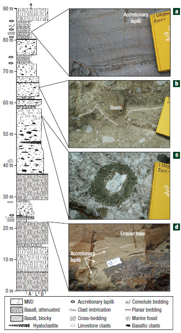
Figure 4. Stratigraphy of mafic volcaniclastic deposits, Daqiao. Rock lithologies are: lava and mafic volcaniclastic deposits (MVDs), with clast size distribution of A=ash, L=lapilli and B=block/bomb. Volcanostratigraphic column represents textural variations in lava flows and MVDs through the Daqiao section. a, Fine-grained, fining-upwards sequence of basaltic pyroclastic surge deposits with accretionary lapilli. The notebook is 19 cm long in all photographs. b, Basaltic bomb with bomb sag in underlying thin (~3 cm) fine-grained basaltic ash layer. c, Limestone-cored basaltic bomb in breccia dominated by angular limestone fragments. d, Autobrecciated lava flow top with overlying accretionary lapilli-bearing tuff filling interstices and forming lag deposits in topographic lows. The ruler in the centre of the photo is 8 inches long.
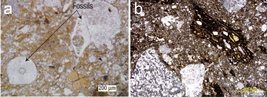
Figure 5. Microscopic photo of the intermediate zone MHDs. a, Mafic hydromagmatic deposit (thin section, plain light) with free microfossils (crinoid and foraminifer) in a basaltic lithic and glass-rich matrix. Basaltic ash partly infills foraminifer (centre right), indicating it was unbound at the time of deposition (basal Daqiao). b, Plastic volcanic materials supported in the marine fossil-bearing carbonate deposits, Xiluo.
Outer zone
In the outer zone, field exposure is only developed an the easternmost edge of the ELIP. The Xiongjiachang section is found here, which is famous for the detailed records of carbon isotope excursions (Wignall et al., 2009) and conodont fossil data (Sun et al., 2010) in the carbonate interlayers that provide evidence of the potential link between the ELIP and the End-Guadalupian extinction. Hydromagmatic deposits are also developed in this section. They formed several meters of palagonite-rimmed clasts that directly overlie a chert layer formed on the top surface of the Maokou Formation (Wignall et al., 2009; Sun et al., 2010). The chert layer is interpreted as deeper marine facies, caused by abrupt down-dropping (Wignall et al., 2009; Sun et al., 2010), and the subsequent palagonte-rimmed clasts, as interpreted by Wignall et al., (2009), are produced from subaqueous, explosive mafic volcanism. This MHD layer is further overlain by tens of meters of flood basalts; after ~10 m interlayers of Maokou limestone, another volcanic cycle was developed, in which ~ 10 m MHDs with the same composition is overlain by ~30 m of columnar-jointed subaerial basalts.
Discussion and conclusion
For most of the 20th century, the ‘Emeishan basalts’ were described and interpreted as exclusively generated by flood eruptions confined in a rift settings, but here is limited evidence to show any rift tectonics associated with the ELIP magmatism. The large igneous province concept and the mantle plume theory were brought into studies of the Emeishan basalts in the early 90’s. Since then, petrological and geochemical studies have provided plenty of data that brought a general consensus that the igneous materials of the ELIP result from a mantle plume origin. Since the uplift model first gave direct evidence from morphological and sedimentary aspect that is preferably interpreted as results of mantle plume uprising which correlated well with the prediction of theoretical studies, the Emeishan LIP once has been regarded as the best example of using LIP record to constrain the existence of an ancient mantle plume.
When the first hydromagmatic sequence was reported in the Daqiao sequence (Ukstins Peate and Bryan, 2008), it was still questioned whether they were possible subaqueous deposits confined in local environment (e.g. lakes) surrounded by a general uplifted background (He et al., 2009). However now that reports of hydroclastic deposits have been confirmed from the very center to the outermost area (as summarized in this article), it is more like that subaqueous eruptions were a wide spread phenomenon across the whole ELIP but rather than a local phenomenon confined to a rift setting (Fig.1). This is consistent with the extensive carbonate platform, a suitable environment for producing abundant hydroclastic deposits, that is the original sedimentary background of the whole Yangtze plate during the Permian.
In both the Shangcang (Dali) section, where thickest ELIP sequence lies, and the Xiongjiachang section, located in the outermost ELIP, a complete transition from deeper submarine to shallower submarine and to subaerial are well recorded. As the whole Yangtze Plate is dominated by carbonate platform deposits at that time, which is only developed in warm and shallower submarine environment, the deeper submarine facies at the initial phase in these two sections imply that an abrupt down-dropping probably occurred at the onset of the ELIP volcanism. The detailed reason why the initial deeper submarine environment occurred remains still unclear. One possible explanation is that, rather than a domal uplift, the surface topography may undergo a subsidence stage when the plume upwelled from the deep mantle, as suggested by recent numerical simulation models (Leng and Zhong, 2010).
For progress on understanding the volcanic evolution and environmental interaction of the ELIP, further work is needed in at least three key aspects: First, the resolution of the volcano-stratigraphy needs to be increased, because an single eruption is always transient; the facies change is probably much more variable both in temporal and spatial dimensions; Second, stratigraphic correlations between these reported areas need to be constructed, because it helps to know the intrinsic linking between the submarine eruptions widely across the whole ELIP; Third, as the importance of eruption pulses during an entire LIP event has been highlighted in the newest review of LIP systems (Ernst, 2014), detailed interpretations of the environment change during the ELIP may provide a useful tool to reveal any eruption pulses, their durations and intervals.
Acknowledgement:
We thank Prof. Richard Ernst and Prof. David W. Peate for their review and valuable suggestions given to this article.
Reference
Ali, J. R., Fitton, J. G., and Herzberg, C., 2010, Emeishan large igneous province (SW China) and the mantle-plume up-doming hypothesis: Journal of the Geological Society, v. 167, no. 5, p. 953-959.
Ali, J. R., Thompson, G. M., Zhou, M.-F., and Song, X., 2005, Emeishan large igneous province, SW China: Lithos, v. 79, no. 3, p. 475-489.
Ernst, R.E., 2014. Large igneous Provinces. Cambridge University Press, 653 p.
Farnetani, C. G., and Richards, M. A., 1994, Numerical investigations of the mantle plume initiation model for flood basalt events: Journal of Geophysical Research: Solid Earth (1978–2012), v. 99, no. B7, p. 13813-13833.
Fisher, R. V., 1984, Submarine volcaniclastic rocks: Geological Society, London, Special Publications, v. 16, no. 1, p. 5-27.
Griffiths, R., and Campbell, I., 1991, Interaction of mantle plume heads with the Earth's surface and onset of small-scale convection: Journal of Geophysical Research, v. 96, no. B11, p. 18295-18218,18310.
He, B., Xu, Y. G., Chung, S. L., Xiao, L., and Wang, Y., 2003, Sedimentary evidence for a rapid, kilometer-scale crustal doming prior to the eruption of the Emeishan flood basalts: Earth and Planetary Science Letters, v. 213, no. 3, p. 391-405.
He, B., Xu, Y. G., Guan, J. P., and Zhong, Y. T., 2010, Paleokarst on the top of the Maokou Formation: Further evidence for domal crustal uplift prior to the Emeishan flood volcanism: Lithos, v. 119, no. 1, p. 1-9.
He, B., Xu, Y. G., Guan, J. P., and Zhong, Y. T., 2011, Reply to comment on'Paleokarst on the top of the Maokou Formation: further evidence for domal crustal uplift prior to the Emeishan flood volcanism'by Bin He, Yi-Gang Xu, Jun-Peng Guan & Yu-Ting Zhong, Lithos 119 1-9, 2010: Lithos, v. 125, p. 1009-1011.
He, B., Xu, Y. G., Wang, Y. M., and Luo, Z. Y., 2006, Sedimentation and lithofacies paleogeography in southwestern China before and after the Emeishan flood volcanism: new insights into surface response to mantle plume activity: The Journal of geology, v. 114, no. 1, p. 117-132.
Isozaki, Y., Yao, J., Ji, Z., Saitoh, M., Kobayashi, N., and Sakai, H., 2008, Rapid sea-level change in the Late Guadalupian (Permian) on the Tethyan side of South China: litho-and biostratigraphy of the Chaotian section in Sichuan: Proceedings of the Japan Academy. Series B, Physical and biological sciences, v. 84, no. 8, p. 344.
Leng, W., and Zhong, S., 2010, Surface subsidence caused by mantle plumes and volcanic loading in large igneous provinces: Earth and Planetary Science Letters, v. 291, no. 1, p. 207-214.
Li, H., Zhang, Z., Ernst, R., Lü, L., Santosh, M., Dongyang, Z., and Zhiguo, C., 2015, Giant radiating mafic dyke swarm of the Emeishan Large Igneous Province: Identifying the mantle plume centre: Terra Nova.
Rainbird, R. H., and Ernst, R. E., 2001, The sedimentary record of mantle-plume uplift: Geological Society of America, Special Paper 352
Shellnutt, J. G., 2014, The Emeishan large igneous province: a synthesis: Geoscience Frontiers, v. 5, no. 3, p. 369-394.
Shen, S., Schneider, J. W., Angiolini, L., and Henderson, C. M., 2013, The international Permian timescale: March 2013 update: The Carboniferous-Permian Transition. New Mexico Museum of Natural History and Science, Bulletin, v. 60, p. 411-416.
Sun, Y., Lai, X., Wignall, P. B., Widdowson, M., Ali, J. R., Jiang, H., Wang, W., Yan, C., Bond, D. P. G., and Védrine, S., 2010, Dating the onset and nature of the Middle Permian Emeishan large igneous province eruptions in SW China using conodont biostratigraphy and its bearing on mantle plume uplift models: Lithos, v. 119, no. 1, p. 20-33.
Ukstins Peate, I., and Bryan, S. E., 2008, Re-evaluating plume-induced uplift in the Emeishan large igneous province: Nature Geoscience, v. 1, no. 9, p. 625-629.
Ukstins Peate, I., and Bryan, S. E., 2009, Pre-eruptive uplift in the Emeishan?: Nature Geoscience, v. 2, no. 8, p. 531-532.
Ukstins Peate, I., Bryan, S., Wignall, P., Jerram, D., and Ali, J., 2011, Comment on'Paleokarst on the top of the Maokou Formation: Further evidence for domal crustal uplift prior to the Emeishan flood volcanism': Lithos, v. 125, no. 3-4, p. 1006-1008.
Wang, Y., Luo, Z., Wu, P., Chen, L., and Hao, J., 2014, A new interpretation of the sedimentary environment before and during eruption of the Emeishan LIP, Southwest China: International Geology Review, v. 56, no. 10, p. 1295-1313.
Wignall, P. B., Sun, Y., Bond, D. P. G., Izon, G., Newton, R. J., Védrine, S., Widdowson, M., Ali, J. R., Lai, X., and Jiang, H., 2009, Volcanism, mass extinction, and carbon isotope fluctuations in the Middle Permian of China: Science, v. 324, no. 5931, p. 1179-1182.
Wignall, P., 2001, Large igneous provinces and mass extinctions: Earth-Science Reviews, v. 53, no. 1, p. 1-33.
Zhang, Z., Mao, J., Saunders, A. D., Ai, Y., Li, Y., and Zhao, L., 2009, Petrogenetic modeling of three mafic–ultramafic layered intrusions in the Emeishan large igneous province, SW China, based on isotopic and bulk chemical constraints: Lithos, v. 113, no. 3, p. 369-392.
Zhu, B., Guo, Z., Liu, R., Liu, D., and Du, W., 2014, No pre-eruptive uplift in the Emeishan large igneous province: New evidences from its ‘inner zone’, Dali area, Southwest China: Journal of Volcanology and Geothermal Research, v. 269, p. 57-67.