January 2010 LIP of the Month
How do your flood basalts grow?
Understanding the facies architecture and rock properties of flood basalts
Dougal A. Jerram, Catherine E. Nelson, and Richard W. Hobbs
Dept. of Earth Sciences, The University of Durham, South Rd., Durham DH1 3LE, UK
email: d.a.jerram@durham.ac.uk
Web: www.dougalearth.com
1 Introduction
When we look in detail at the internal architecture of flood basalts, it is clear that a large igneous province (LIP) does not have a simple layer-cake stratigraphy of lava flows. If we look at examples of sections through different provinces we can see clear variations in vertical stacking (e.g. Figure 1a). There are several ways this variation may develop: through eruption into different environments, eruption flux and/or proximal to distal variations (e.g. Figure 1b). Within single provinces we can see clear scales of observation which record different hierarchies of heterogeneity, such as the example given in figure 2 from Jerram and Widdowson (2005). So how do we start to characterise such variations and look into how our flood basalts grow? In this “LIP of the Month” we briefly comment on the growing field of facies analysis in flood basalts.
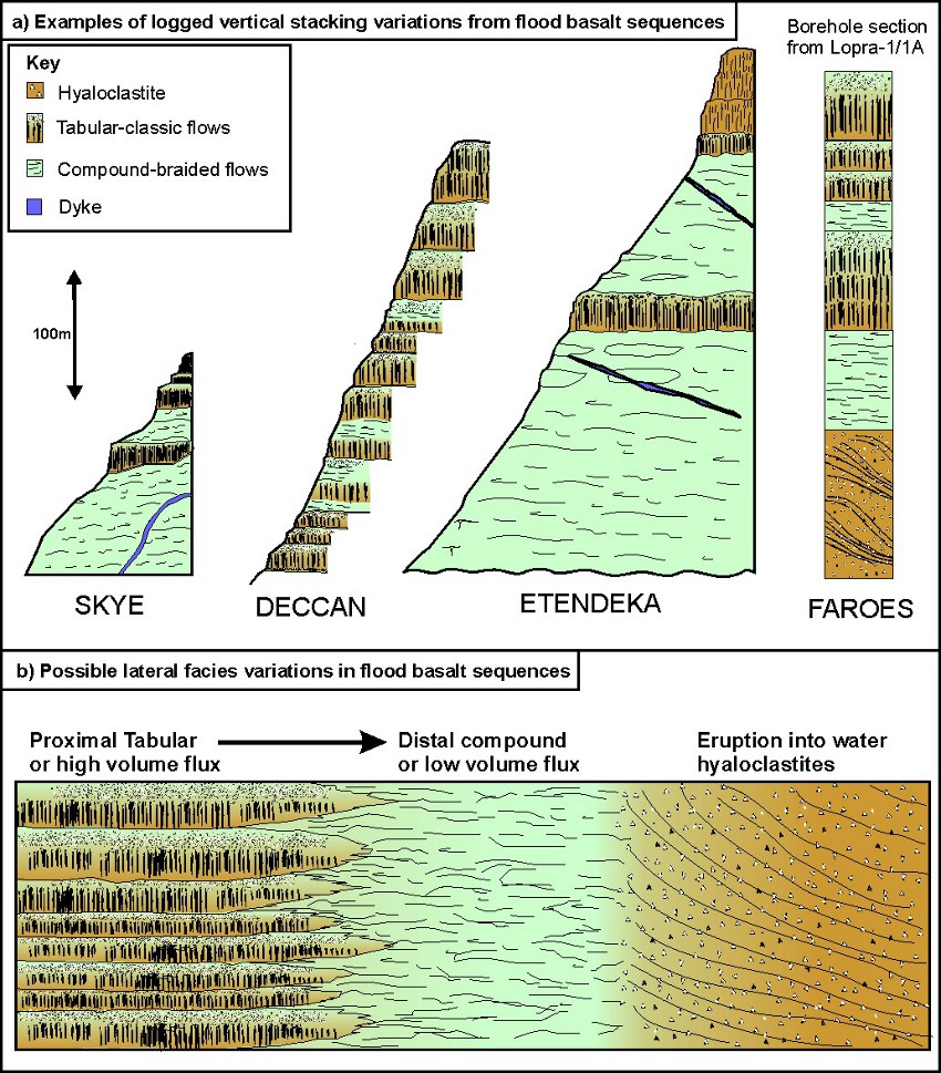
Figure 1. A) Logged sections through flood basalt provinces showing vertical heterogeneities of different facies. B) Schematic conceptual diagram looking at possible lateral facies variations (see Nelson et al., 2009a).
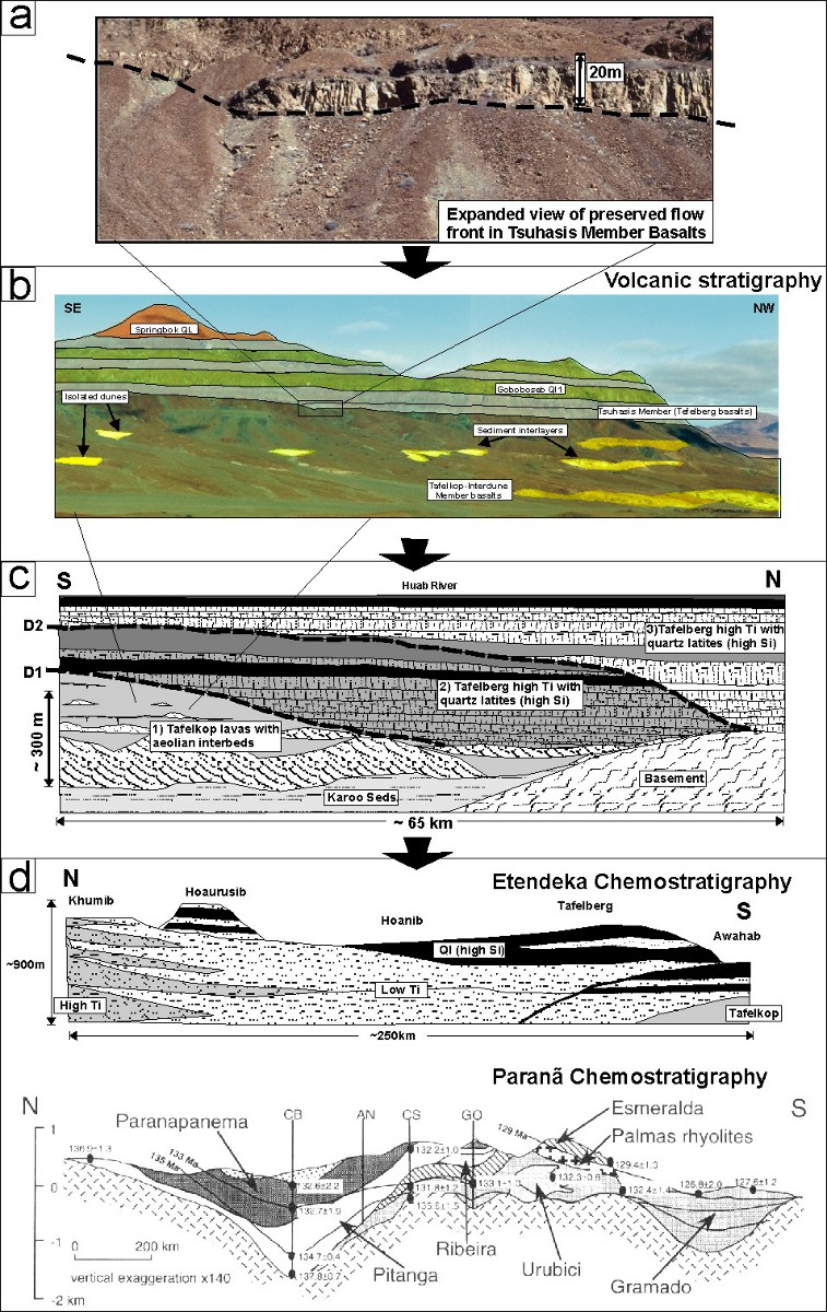
Figure 2. Scales of heterogeneity preserved in the Paranã-Etendeka flood basalt sequence a) meters, b) 10-100s meters, c) kms, d) 100-1000 km (from Jerram & Widdowson 2005).
2 Detailed facies analysis in flood basalt terrains
The facies concept, used extensively in describing sedimentary rocks, was first applied to volcanic rocks by Cas and Wright (1996). A facies is defined as a body of rock with specified characteristics (Reading, 1986), and these characteristics are definable and distinguish the rock from other facies. The facies is the product of a particular set of conditions (Cas and Wright 1996). In volcanic successions different styles of volcanism, different magma compositions, or differences in rates of eruption, produce the various facies (e.g. Jerram, 2002). An understanding of the evolution of a province can thus be gained from facies analysis.
Facies variation has been observed at scales from the individual lava flow to the seismic scale. Classification schemes have been developed by Single and Jerram (2004) (Figure 3) at the intrafacies scale (within flow variation), at the facies scale (e.g. Jerram, 2002) (Figures 4 & 5), and at the seismic scale (e.g. Planke, 2000) (see summary figure 6). Work has also been focused on the rock properties of these different facies types to help understand geophysical responses (e.g. Nelson et al., 2009a). Although these schemes are not fully inclusive of all facies types found in flood basalt provinces, they provide a conceptual means of defining volcanic heterogeneities and comparing between different flood basalt provinces, providing a systematic framework for observations (see Nelson et al., 2009b).
2.1 Scales of facies heterogeneity 1 – within flow intrafacies
One of the earliest studies of the physical volcanology of flood basalt lavas was by Self et al. (1997). In attempting to understand lava emplacement mechanisms, they divided flows into an upper crust, core and basal zone, based on vesicle patterns, jointing style and petrographic texture. A similar approach was taken by Single and Jerram (2004), who developed a classification scheme for small-scale heterogeneity within lava flows, which built on the core-crust observations to include bole horizons, lava tubes, small intrusions and so on. Within this scheme, known as the ‘intrafacies’ scheme (Single and Jerram 2004), information on rock properties important for geophysical modelling are also included, providing a systematic method of characterising features in lava sequences and allowing comparisons to be made between provinces. The intrafacies classification scheme, explained further below, was based on observations made in the Talisker Bay area of Skye, part of the North Atlantic Igneous Province. The intrafacies classification scheme is based on field observations and covers heterogeneities visible at the smallest scale of field observation: the 0.1-10m scale. Intrafacies components are identified by changes in properties such as fracturing, vesiculation, shape of the feature, and the presence of palaeosols. A summary of the different intrafacies components is shown in Figure 3.
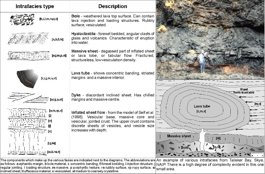
Figure 3. Within lava flow heterogeneities ‘Intra-Facies’ (from Single and Jerram 2004).
2.2 Scales of facies heterogeneity 2 – flow facies and facies associations
Jerram (2002) outlined the major facies types and facies associations providing a systematic way of describing heterogeneity at the metre to kilometre scale (summarised in Figure 4). Facies types described in this scheme include different types of lava flow, hyaloclastites, ponded flows, sills and dykes, based on observations made in the Etendeka, Karoo, Columbia River, Ethiopia, Deccan and British Tertiary provinces. Examples are shown in Figure 5.
The facies classification scheme has been applied successfully in several flood basalt provinces. In the NAIP, Passey and Bell (2007) characterised the morphologies of the Faroe Islands Basalt Group, incorporating a facies approach such as the scheme of Jerram (2002). The three main eruptive sequences demonstrate a variety of different facies architectures. The lowermost is dominated by a tabular-classic facies architecture, which indicates that the flows were erupted as single continuous flows from fissure systems. The middle sequence consists mainly of compound-braided flows, suggesting a different eruptive style where flows were not erupted continuously, but at longer time intervals from separate shield volcanoes. The uppermost sequence has a mixture of the two facies architectures. Hyaloclastite and sill facies are also present. Single (2004) also studied the NAIP – in this case, the facies architecture of the Talisker Bay area, Skye. A series of tabular-classic flows was found overlying compound-braided flows, with a transitional sequence in between.
Jerram and Widdowson (2005) showed how facies variations may successfully be compared across different provinces. The architecture of the Deccan, the Paranã-Etendeka and the NAIP was considered. Despite many differences between the provinces, there are some similarities. All show initial low-volume eruptions followed by a main phase of relatively short duration (1-5 Ma). This main phase is characterised by large volume, extensive tabular flows.
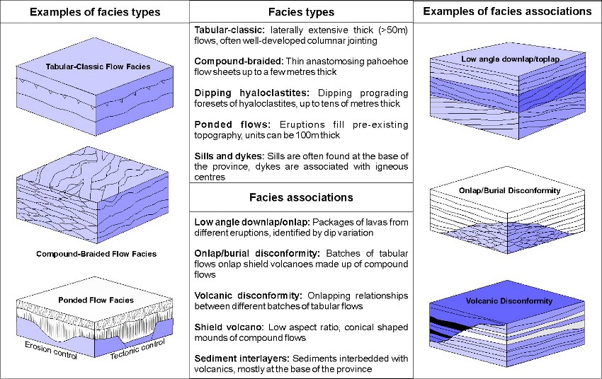
Figure 4. Summary of key facies and facies associations (see Jerram et al., 2000).
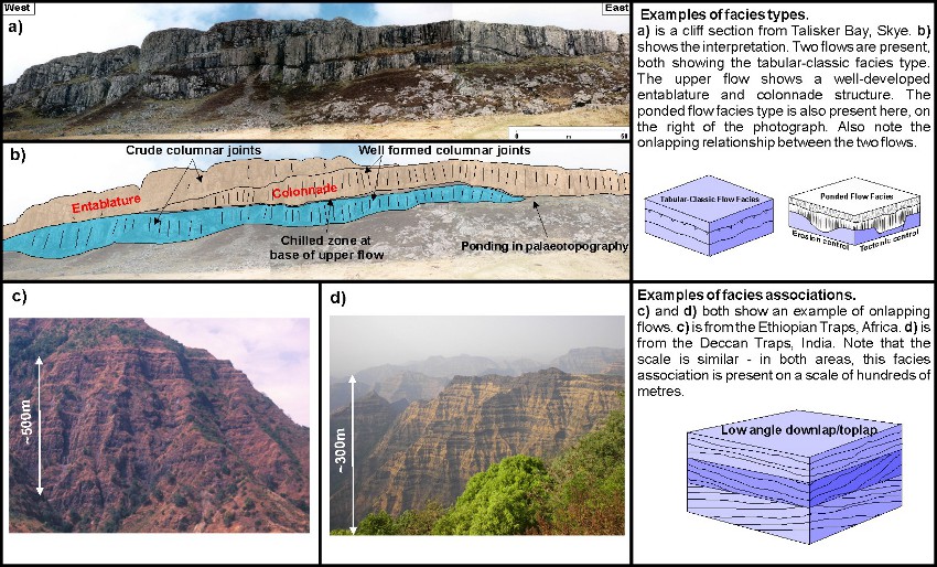
Figure 5. Examples of the key flood basalt facies. A-B) tabular and ponded examples from Skye. C-D onlap and downlap in thick sequences from Ethiopia and the Deccan.
2.3 Scales of facies heterogeneity 3 – seismic scale
Seismic imaging through flood basalts can pick out features greater than 50 m thick, so individual lava flows are not identified. A certain amount of heterogeneity is, however, still apparent. This has been characterised by Planke et al. (2000) (see Figure 6), who developed a facies classification scheme at the seismic scale which is based on seismic reflection data from the Atlantic and Western Australia volcanic rifted margins. The different facies were identified by their shape, and the reflection characteristics of their boundaries and internal reflections.
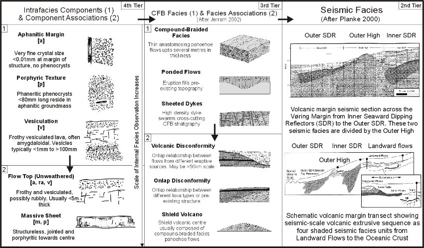
Figure 6. Summary of different facies preserved in flood basalt provinces at scales from within flow to seismic (from Single and Jerram 2004).
3 3D geological models
As can be seen from the facies associations of Jerram (2002), heterogeneity within a flood basalt sequence is not limited to 1D layering. The protracted build-up of lava packages results in marked lateral variations within the provinces (e.g. Jerram & Widdowson 2005), and these lateral facies variations exist and must be taken into account in geophysical modelling of areas with flood basalt cover. Constructing 3D models allows improved geophysical modelling (see Section 3) as well as improved understanding of the evolution of flood basalt provinces. As yet, limited examples of 3D geological models of flood basalt basins exist but initial work on reconstructing onshore flood basalt basin analogues are showing good promise for capturing further information on heterogeneities and facies distributions as well as providing realistic geometries for geophysical modelling. Jerram & Robbe (2001) produced a 3D geological model in GoCad for the Etendeka region in Namibia (Figure 7a-c), and were able to use this to map out a palaeo-shield volcanic feature in the sequence. Further detailed examples have been constructed for the Skye lavas in the British Palaeogene (e.g. Single & Jerram 2004) (Figure 7d).
A novel approach that has proved successful is to use terrestrial laser scanning equipment to capture the heterogeneity in an outcrop. “Virtual outcrops” consisting of point clouds coloured from digital photos can be viewed and analysed in 3D, and interpretations can be built into full 3D models. An example of the virtual outcrop of the Skye Main Lava Series is given in Figure 8. (Nelson et al., Geopshere submitted).
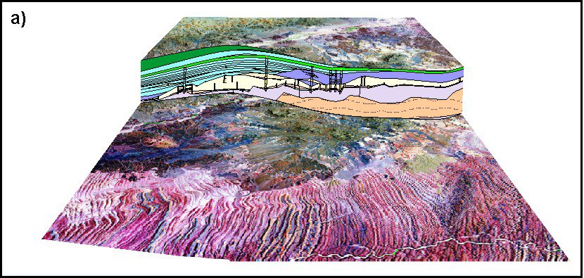
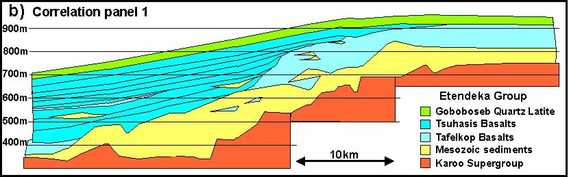
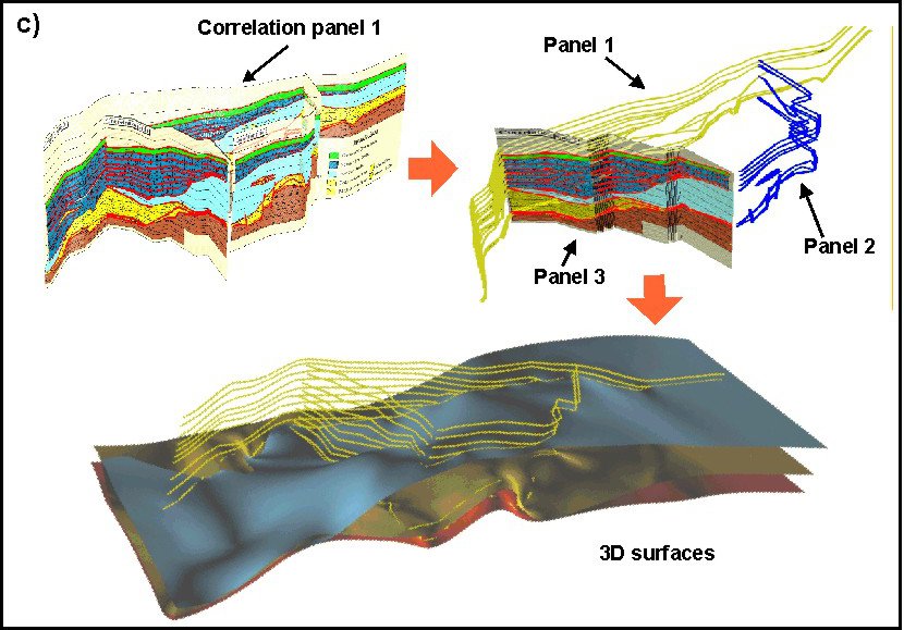
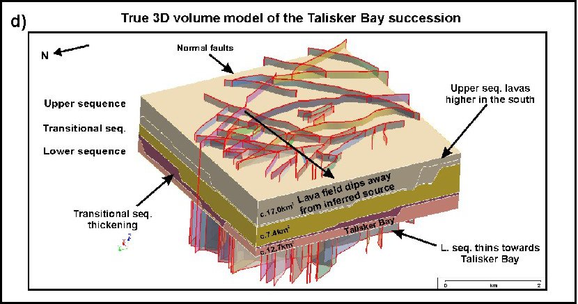
Figure 7. 3D models of flood basalt sequences. A-C) the model construction from the Etendeka outcrops in NW Namibia (Jerram & Robbe 2001). D) a large scale model of the Talisker Bay succession (Single & Jerram 2004).
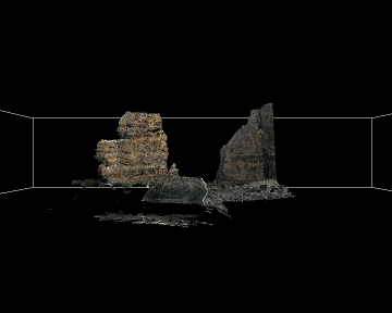
Figure 8. Animated virtual outcrop model of lava sequences at Talisker Bay, Skye, Scotland. Technology like this will greatly improve our data and understanding of the 3D heterogeneities present in lava flows (Nelson et al., Geosphere – submitted).
4 Linking facies with geophysics
The study of the relationships between flood basalt facies types is particularly important when considering offshore examples. Geometrical stacking patterns may be seen on seismic scales, so if we know what causes these patterns in well-exposed onshore examples, we can identify facies offshore. Characteristic stacking patterns include disconformities, downlap and shield volcanoes. New studies are starting to link offshore observations with onshore sequences (e.g. Jerram et al. 2009), and is becoming clear that knowledge of the types of volcanic facies in flood basalts can help link onshore to offshore data (e.g. Figure 9).
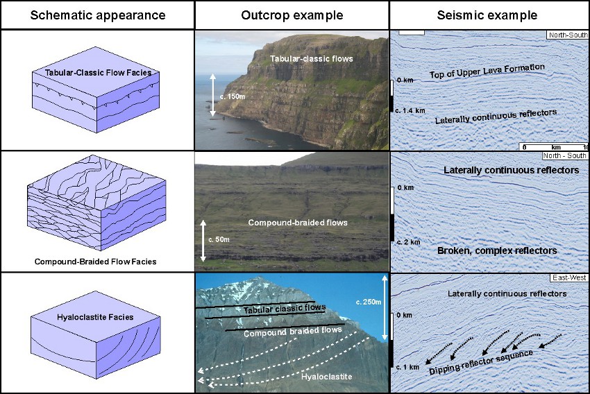
Figure 9. Linking the key facies types from onshore to offshore examples (see Jerram et al., 2009). As seismic datasets through flood basalts improve, our ability to map out facies will be enhanced.
To improve sub-basalt imaging, it is necessary to understand the effect of a layered, heterogeneous basalt sequence on the seismic wave. This is currently poorly constrained – it is known that a flood basalt sequence causes scattering and preferentially attenuates high frequencies (e.g. Martini et al., 2005; Maresh et al., 2006). Knowledge of how the heterogeneity within the basalt affects the seismic wave will enable optimisation of the seismic method. It is therefore important to understand the way in which heterogeneities within volcanic rocks are manifest with different volcanic facies. Nelson et al. (2009a) have used different volcanic facies from known distributions in boreholes to compare to their velocity distribution (Figure 10). This shows different, characteristic velocity distributions for each facies.
5 Summary
There is a growing field of study in LIPs which looks at how the large sequences of volcanics are preserved in terms of their volcanic facies and how such facies change both spatially and temporally as we build up a LIP from bottom to top. This is being driven in part by volcanological studies and in part by a need to understand and explore large sequences of flood basalts in an off shore setting. This LIP of the Month hopes to expose the community to some of the ideas and work going on in this area, and looks forward to future studies which bring our LIPs closer towards full 3D geological facies models.
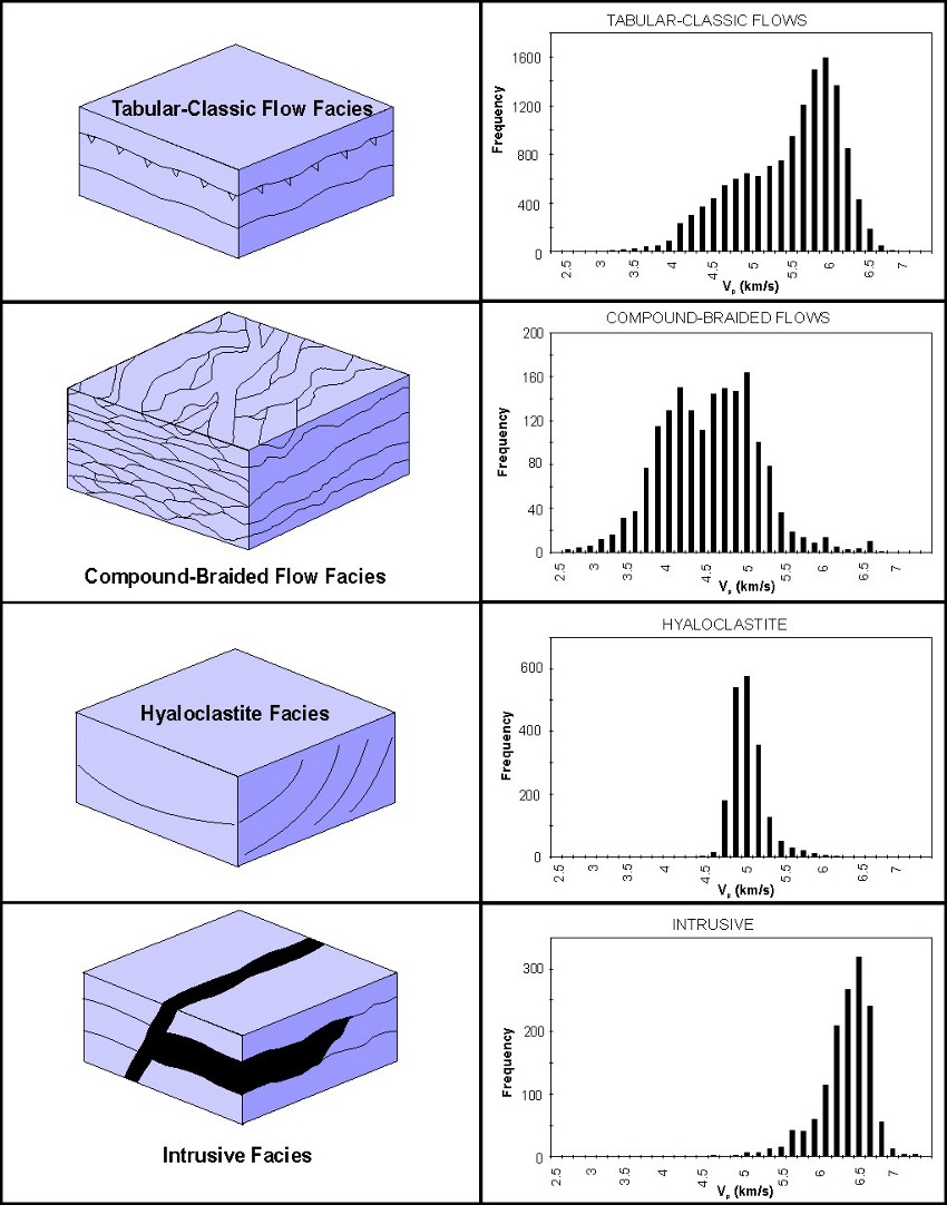
Figure 10. Velocity profiles through key volcanic facies (from Nelson et al., 2009). Note each facies has a distinct distribution which can be recognised from well data.
References
Cas, R.A.F., Wright, J.V., 1996. Volcanic successions: modern and ancient. Chapman and Hall, London.
Jerram, D. A., Robbe, O., 2001. Building a 3-D geologic model of a Flood Basalt: an example from the Etendeka, NW Namibia. Electronic Geosciences 6:1.
Jerram, D.A., 2002. Volcanology and facies architecture of flood basalts. In: Menzies, M.A., Klemperer, S.L., Ebinger, C.J., Baker, J. (eds) Volcanic Rifted Margins. Geological Society of America Special Paper 362, 121-135.
Jerram, D.A., Widdowson, M., 2005. The anatomy of Continental Flood Basalt Provinces: geological constraints on the processes and products of flood volcanism. Lithos 79, 385-405.
Jerram, D. A., Single, R. T., Hobbs, R. W. & Nelson, C. E. 2009.Understanding the offshore flood basalt sequence using onshore volcanic facies analogues: an example from the Faroe–Shetland basin Geol. Mag. 146 (3), pp. 353–367.
Maresh, J., White, R.S., Hobbs, R.W., Smallwood, J.R., 2006. Seismic attenuation of Atlantic margin basalts: Observations and modelling. Geophysics 71, B211-B221.
Martini, F., Hobbs, R.W., Bean, C.J., Single, R.T., 2005. A complex 3D volume for sub-basalt imaging. First Break 23, 41-51.
Nelson, C.E., Jerram, D.A., and Hobbs, R.W., 2009a, Flood basalt facies from borehole data: implications for prospectivity and volcanology in volcanic rifted margins: Petroleum Geoscience, v. 15, p. 313-324.
Nelson, C.E., Jerram, D.A., Single, R.T., and Hobbs, R.W., 2009b, Understanding the facies architecture of flood basalts and volcanic rifted margins and its effect on geophysical properties., in Varming, T., and Ziska, H., eds., Faroe Islands Exploration Conference: Proceedings of the 2nd Conference, Annales Societatis Scientarium Faroensis, supplementum, Volume 48, p. 84-103.
Nelson, C.E., Jerram, D.A., Hobbs, R.W., Terrington, R., and Kessler, H. Reconstructing flood basalt lava flows in 3D using terrestrial laser scanning. Geosphere, submitted.
Planke, S., Symonds, P.A., Alvestad, E., Skogseid, J., 2000. Seismic volcanostratigraphy of large-volume basaltic extrusive complexes on rifted margins. Journal of Geophysical Research 105, 19335-19351.
Passey, S. R. & Bell, B. R. 2007. Morphologies and emplacement mechanisms of the lava flows of the Faroe Islands Basalt Group, Faroe Islands, NE Atlantic Ocean. Bulletin of Volcanology 70; 139-156.
Reading, H.G. 1986. Sedimentary Environments and Facies. Second Edition, Blackwell Scientific Publications, Oxford.
Self, S., Thordarson, T., Keszthelyi, L., 1997. Emplacement of continental flood basalt lava flows, in Mahoney, J. J., Coffin, M. F., eds., Large Igneous Provinces: Continental, Oceanic, and Planetary Flood Volcanism: AGU Geophysical Monograph 100, 381-410.
Single, R.T., Jerram, D.A., 2004. The 3-D facies architecture of flood basalt provinces and their internal heterogeneity: examples from the Palaeogene Skye Lava Field. Journal of the Geological Society, 161, 911-926.