August 2019 LIP of the Month
The Warnie Volcanic Province: An Australian Intraplate (Not-That-Large) Igneous Province
Jonathon P.A. Hardmana, Simon P. Holfordb, Nick Schofielda, Mark Bunchb, Daniel Gibbinsc
a Department of Geology and Petroleum Geology, University of Aberdeen, Aberdeen, AB24 3FX, UK
b Australian School of Petroleum, University of Adelaide, Adelaide, SA 5005, Australia
c Vintage Energy, 58 King William Road, Goodwood, SA 5034, Australia
Email contacts: simon.holford@adelaide.edu.au, n.schofield@abdn.ac.uk, Jonathon.hardman@cgg.com
Extracted From: Hardman, J.P., Holford, S.P., Schofield, N., Bunch, M. and Gibbins, D., 2019. The Warnie volcanic province: Jurassic intraplate volcanism in Central Australia. Gondwana Research.
For full details, see this reference
Introduction
The Warnie Volcanic Province (WVP) is the name given to a >7500 km2 suite of igneous rocks located in an intraplate setting in Central Australia. Despite lacking in size, the province has large implications for our understanding of Australia during the Mesozoic.
Our detailed understanding of the WVP is due to the location of the igneous rocks within the largest conventional onshore hydrocarbon-producing region in Australia (Hall et al., 2016). Igneous rocks of suspected late Triassic-Jurassic age were sporadically encountered by drilling over the past 35 years, however, the extent and nature of the volcanism were largely unclear (Short, 1984; Boothby, 1986; Bucknill, 1990; Allen, 1998). In the early 2000s, hydrocarbon exploration focused in on the deeper parts of the Cooper Basin leading to the acquisition of well and seismic data in one of the main depocentres, the Nappamaerri Trough (Hillis et al., 2001; Pitkin et al., 2012; Khair et al., 2013; Scott et al., 2013; Hall et al., 2016). With this new data, in particular high-quality 3D seismic data, the WVP began to be unearthed.
Regional Setting of the Warnie Volcanic Province
The WVP is located in Southwest Queensland. The geological history of the region is defined by a series of intracratonic basins that are stacked on top of each other; the Warburton, Cooper, Eromanga and Lake Eyre. The Cooper Basin is Permian-Triassic basin that covers an area of 130,000 km2 in northwest South Australia and southwest Queensland. Following termination of Cooper Basin deposition, the Eromanga Basin began to form in the Jurassic. The Eromanga Basin is an intracratonic sag basin formed, in part, due to dynamic topography created by the subduction of the Pacific Plate beneath Australia (Gallagher & Lambeck, 1989; Russel & Gurnis, 1994). This broad-scale sag covers an area of ~1,000,000 km2 across central, north and eastern Australia, however, it is in southwest Queensland that the WVP formed.
During the eruption of the WVP, southwest Queensland consisted of sand-dominated braided fluvial systems that drained into lowland lakes and swamps. Sediment supply is thought to have been a product of sediment sourced from stable cratonic regions to the south with additional lithic input from arc volcanism located further east, another by-product of the subducting Pacific plate (Boult et al., 1997).
Overview of the Igneous Rocks
The WVP was described through a combination of seismic, well, gravity and magnetic data. Within the province, three distinct types of igneous rocks have been recognised.
Most commonly, monogenetic volcanic activity was recognised in the province. Within one seismic survey (the Winnie 3D survey, covering an area of ~1050 km2), 100 ≤4 km2 monogenetic volcanoes were identified within the Jurassic stratigraphy. Typically, they are elongated in an NW-SE direction mirroring faulting that formed during the sag of the basin. In twelve instances these volcanoes were linked to lava flows that are ~2-7 km long and 0.5-2.5 km wide, again reflecting the elongate nature of the igneous rocks. Two wells were identified where these extrusive volcanics were intersected and they are characteristically basaltic and tabular in nature. However, in the south of the WVP, 120 m of volcaniclastic and volcanic rocks intersected by the Kappa-1 well appear chloritized, suggesting hydrothermal alteration of extrusive volcanism in parts of the province (Renaut et al., 2002).
Much less common are intrusive igneous rocks. In the Warnie East 1 well, igneous rocks were encountered at 2103 m depth within the Permian Toolachee Formation, an oddity considering the Jurassic-aged extrusive volcanism. The 65 m basalt is fine-grained and dominated by plagioclase laths intergrown with augite (Boothby, 1986). Most telling are vitrinite reflectance samples taken above and below the basalt that show a 4.5% increase while typical Permian samples are 1.5-1.75% (Smith, 1987). Uniform heating either side of the basalt, coupled with its stratigraphic position suggest that it is an igneous intrusion. In seismic, other igneous intrusions are observed to cross-cut Triassic to Jurassic strata. 14 were identified in the Winnie 3D survey and they largely occur at shallow depths (105-210 m) below the palaeosurface. While most of the intrusions are comparable in size to the lava flows, there is a spectacular single intrusion, 14 km long and 8 km wide in the northeast of the survey.
Gravity and magnetic surveys of Southwest Queensland help constrain the areal extent of the WVP. The correspondence of <8 km2 1VD magnetic anomalies and high gravity in the vicinity of the igneous rocks recognised in seismic and well data suggest that these regional surveys can aid in locating unidentified intraplate volcanism. Further gravity and magnetic highs elsewhere in the Cooper Basin suggest that the areal extent of the province could extend beyond the igneous rocks identified in seismic and well data.
Implications for Australia during the Mesozoic
Through a combination of age relationships identified in the seismic and well data with previous geochemical analyses, it has been concluded that the Warnie Volcanic Province erupted within a broad age range between 180 and 160 Ma during the middle Jurassic. Plate reconstructions of Australia during the Jurassic suggest that the WVP was situated at least 750 km away from the oceanic trench of the subducting Pacific plate (Veevers & Conaghan, 1984; Ivanov et al., 2017). The intraplate setting of the WVP makes identifying a mechanism by which the volcanic province formed difficult, particularly because the Eromanga Basin was undergoing a relatively inactive phase of thermal sag (Gallagher & Lambeck, 1989).
Several mechanisms were considered, including:
- Asthenospheric upwelling due to extension
- A mantle plume
- Local-scale mantle convection
Ultimately, local scale mantle convection was deemed the most likely candidate, however, in order to ascertain the cause of this convection the WVP was considered in the context of the pervasive Mesozoic volcanic activity taking place across the east coast Australia. Volcanic activity was notable in the Sydney Basin (McDougall & Wellman, 1976, Embleton et al., 1985; Pells, 1985), the Gunnedah Basin (Sutherland, 1978; Pratt, 1998; Gurba & Weber, 2001), in New South Wales (Dulhunty, 1976; Embleton, 1985; Black, 1998, Warren et al., 1999) and throughout Victoria and Tasmania (Sutherland, 1978; McDougall & Wellman, 1976; Veevers & Conaghan, 1984; Bromfield et al., 2007; Ivanov et al., 2017). Furthermore, evidence for Jurassic volcanic activity is recognised in the sedimentary basins of eastern Australia, with volcanic arc-derived sediment and volcanogenic zircons in the Eromanga Basin (Bryan et al., 1997; Boult et al., 1998) and silicic tuffs in the Surat Basin (Wainman et al., 2015).
Some of this volcanic activity can be related to the tectonic setting of Eastern Australia during the Mesozoic, as the subduction of the Pacific Plate caused back-arc rifting, asthenospheric upwelling and, in places, arc-volcanism. It is suggested that the WVP is an extension of this tectonic activity, as the subducting pacific plate stimulated mantle flow beneath Australia which led to localised mantle convection in southwest Queensland. Excitingly, the presence of an overlooked intraplate volcanic province in an area so intensely studied for decades suggests that many more intraplate volcanic provinces may be waiting to be unearthed elsewhere.
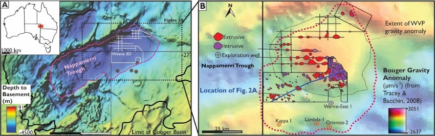
Figure 1. A Location map highlighting the study area within Australia. Outline of the Cooper Basin, Nappamerri Trough and the areal extent of the Warnie Volcanic Province is superimposed on top of a depth to top Basement map adapted from SA Department for Manufacturing, Innovation, Trade, Resources and Energy (2003). B Detailed map of the Warnie Volcanic Province. Bouguer gravity anomaly from the Queensland Government's data repository (Adapted from Hardman et al., 2019).
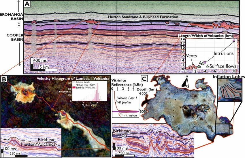
Figure 2. A Vertical TWT seismic section of the Nappamerri Trough, taken from the Winnie 3D survey. B Spectral decomposition of surface flows from within the Winnie 3D survey. TWT seismic section highlights the seismic facies of extrusive volcanics. Velocity histogram constructed using velocity data from the Lambda-1 well. C Overview of Intrusions in the WVP. Spectral decomposition and vertical TWT section of the 140 km2 igneous intrusion. VR Profile for the Warnie East 1 well showing uniform heating above and below intersected intrusion (Adapted from Hardman et al., 2019).
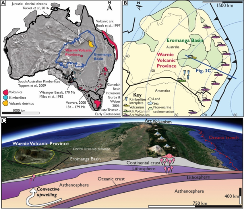
Figure 3. A Map of Australia, superimposed with the location of middle to late Jurassic volcanics in eastern Australia, described in the text. The base map is a magnetics map used to highlight the Great Artesian Basin. B Palaeogeographic map of Australia in the middle Jurassic, highlighting the tectonic nature of the different volcanics. C Oblique view of Australia, highlighting the subducting pacific slab and associated convective upwelling (Adapted from Hardman et al., 2019).
References
Allen, P., 1998.Kappa 1 Well Completion Report (Compiled for Santos Limited).
Black, L.p., 1998.SHRIMP zircon UIPb isotopic age dating of samples from the Dubbo 1:250000 Sheet area, batch 2. Geological Survey of New South Wales, File GS1998/127 (unpublished).
Boothby, P.G., 1986.Warnie East 1 Well Completion Report. Compiled for Delhi PetroleumPty Ltd.
Boult, P.J., Ryan, M.J., Michaelsen, B.H., McKirdy, D.M., Tingate, P.R., Lanzilli, E., Kagya, M.L.,1997.The Birkhead-Hutton (!) Petroleum System of the Gidgealpa Area. EromangaBasin, Australia.
Boult, P.J., Lanzilli, E., Michaelsen, B.H., McKirdy, D.M., Ryan, M.J., 1998.Anewmodelforthe Hutton/Birkhead reservoir/seal couplet and the associated Birkhead-Hutton (!)petroleum system. The APPEA Journal 38, 724–744.
Bromfield, K.E., Burrett, C.F., Leslie, R.A., Meffre, S., 2007.Jurassic volcani-clastic basalticandesite - dolerite sequence in Tasmania: new age constraints for fossil plants fromLune River. Aust. J. Earth Sci. 54, 965–974.
Bryan, S.E., Constantine, A.E., Stephens, C.J., Ewart, A., Schön, R.W., Parianos, J., 1997.EarlyCretaceous volcano-sedimentary successions along the eastern Australian continentalmargin: Implications for the break-up of eastern Gondwana. Earth Planet. Sci. Lett.153, 85–102.
Bucknill, M., 1990.Orientos 2 Well Completion Report (Compiled for Delhi Petroleum PtyLimited).
Dulhunty, J.A., 1976.Potassium-argon ages of igneous rocks in the Wollar-Rylstone re-gion, New South Wales. Royal Society of New South Wales, Journal and Proceedings109, 35–39.
Embleton, B.J.J., Schmidt, P.w., Hamilton, L.H., Riley, G.H., 1985.Dating volcanism in theSydney Basin; evidence from K-Ar ages and palaeomagnetism. Geological Society ofAustralia, Journal 23, 243–248.
Gallagher, K., Lambeck, K., 1989.Subsidence, sedimentation and sea-level changes in theEromanga Basin. Australia,Basin Research2, 115–131.
Gurba, L.W., Weber, C.R., 2001.Effects of igneous intrusions on coalbed methane poten-tial. Gunnedah Basin, Australia,International Journal of Coal Geology46, 113–131.
Hall, L.S., Hill, A.J., Troup, A., Korsch, R.J., Radke, B.M., Nicoll, R.S., Palu, T., Wang, L., Stacey,A., 2016.Cooper Basin Architecture and Lithofacies (Geoscience Australia).
Ivanov, A.V., Meffre, S., Thompson, J., Corfu, F., Kamenetsky, V.S., Kamenetsky, M.B.,Dementrova, E.I., 2017.Timing and genesis of the Karoo-Ferrer large igneous prov-ince: New high precision U-Pb data for Tasmania confirm short duration of themajor magmatic pulse. Chem. Geol. 455, 32–43.
Khair, H.A., Cooke, D., Hand, M., 2013.The effect of present day in situ stresses and paleo-stresses on locating sweet spots in unconventional reservoirs, a case study fromMoomba-Big Lakefields, Cooper Basin, South Australia. Journal of Petroleum Explora-tion and Production Technology 3 (4), 207–221.
McDougall, I., Wellman, P., 1976.Potassium argon ages for some Australian Mesozoic ig-neous rocks. J. Geol. Soc. Aust. 23, 1–9.
Pells, P.J.N., 1985.Engineering Geology of the Sydney Region, 407 pp. Routledge, London.
Pitkin, M.C., Wadham, T.H., McGowen, J.M., Thom, W.W., 2012, January.Taking the FirstSteps: Stimulating the Nappamerri Trough Resource Play. InSPE Asia Pacific Oil andGas Conference and Exhibition, Society of Petroleum Engineers.
Pratt, W., 1998.Gunnedah Coalfield: Notes to accompany the Gunnedah Coalfield re-gional geology (north and south maps). Report GS1998/505. New South Wales De-partment of Mineral Resources. Geological Survey of New South Wales, Sydney(113 pp).
Renaut, R.W., Jones, B., Tiercelin, J.J., Tarits, C., 2002.Sublacustrine precipitation of hydro-thermal silica in rift lakes: evidence from Lake Baringo, central Kenya Rift Valley. Sed-iment. Geol. 148 (1–2), 235–257.
Russell, M., Gurnis, M., 1994.The planform of epeirogeny: vertical motions of Australiaduring the Cretaceous. Basin Res. 6 (2–3), 63–76.
SA Department for Manufacturing, Innovation, Trade, Resources and Energy (2003)
Scott, M.P., Stephens, T., Durant, R., McGowen, J., Thom, W., Woodroof, R., 2013, November. Investigating Hydraulic Fracturing in Tight Gas Sand and Shale Gas Reservoirs in the Cooper Basin. In SPE Unconventional Resources Conference and Exhibition-Asia Pacific, Society of Petroleum Engineers.
Short, D.A., 1984. Lambda no.1 well Completion Report. Compiled for Delhi Petroleum Pty. Ltd.
Smith, 1987. Vitrinite Reflectance/Maceral Analysis of the Warnie East 1 Well.
Sutherland, F.L., 1978. Mesozoic-Cainozoic volcanism of Australia. Tectonophysics 48 (3–4), 413–427
Veevers, J.J., Conaghan, P.J., 1984. Phanerozoic Earth History of Australia. Oxford University Press, USA.
Wainman, C.C., Mccabe, P.J., Crowley, J.L., Nicoll, R.S., 2015. U–Pb zircon age of the Walloon Coal measures in the Surat Basin, southeast Queensland: implications for paleogeography and basin subsidence. Australian Journal of Earth Sciences, v. 62, 807–816.
Warren, A.Y.E., Barron, L.M., Meekin, N.S., Morgan, E.J., Raymond, O.L., Cameron, R.G., Colquhoun, G.P., 1999. Mesozoic igneous rocks. Compilers. In: Meakin, N.S., Morgan, E.J. (Eds.), Dubbo 1:250 000 Geological Sheet SI/55-4, 2nd Edition,